26 September 2017

Back in gear, and watching two active hurricanes

The last update and blog post I wrote was on September 7.  Between Hurricane Irma house preparations, subsequent loss of power and internet, then a 10-day vacation to Ireland, I have been largely offline since then. I started writing these updates in 1996, so this is the 22nd year, and in all that time, I never had a lapse this long during such heightened activity.  But I have no doubt that if you needed the most current information and forecasts that the NHC website was your place to go, and for blog posts to summarize activity, the Capital Weather Gang is a great stop.  I hope everyone reading this who was affected by the recent tropical cyclones is doing well and getting back to normal, but I realize that in some places, that may take a long time.

A lot has happened since the 7th (Katia's Mexico landfall, Irma's Florida landfall, Jose's long loop, Lee's little loop, Maria's landfall on the northern Leewards and Puerto Rico).  To summarize the activity from Irma through Maria, here is a map showing all of their tracks... note that Lee (14L) and Maria (15L) are still active and are both hurricanes:


For current activity, Category 1 Hurricane Maria is centered just off the North Carolina coast... tropical storm and storm surge warnings are in effect for the Outer Banks.  It is forecast to move away from the U.S. east coast.  Category 2 Hurricane Lee is centered about 1200 miles east of Maria and is not a threat to any land.

Hurricane Maria and Hurricane Lee on Tuesday afternoon.
Additional tropical cyclone development is unlikely within the next five days, but there is a disturbance that will crawl across south Florida from Friday through Monday.  It will bring elevated chances of thunderstorms and heavy rain... though the odds of it becoming even a tropical depression are slim.

Seven-day rainfall forecast, valid Tuesday morning through next Tuesday morning. (NOAA/WPC)
The season has now had 13 named storms, 8 hurricanes, and 4 major hurricanes... and in terms of ACE (Accumulated Cyclone Energy), the season is at a whopping 242% of average for this date. We are on par to compete with the hyper-active 1995 and 2004 seasons (the 2005 season is in a league of its own).  Unfortunately, the season has also come with numerous landfalls -- only Arlene, Don, Gert, Jose, and Lee have not passed directly over land.


07 September 2017

Category 5 Irma stays on perilous path toward Florida, hurricane watch issued

My Thursday morning update on Hurricane Irma and other activity across the tropics (Hurricane Jose and Hurricane Katia) is available on the Capital Weather Gang blog:

Category 5 Irma stays on perilous path toward Florida, hurricane watch issued

I will probably post something on Friday, and perhaps Saturday, but I do not expect to have power or an internet connection by Saturday evening. Please stay tuned to the National Hurricane Center for the latest.


06 September 2017

Extreme Category 5 Irma crashes into Caribbean, sets sights on Florida and Southeast U.S.

My Wednesday morning update on Hurricane Irma is available on the Capital Weather Gang blog:

Extreme Category 5 Irma crashes into Caribbean, sets sights on Florida and Southeast U.S.

Tropical Storm Jose is also out there east of Irma, and Tropical Storm Katia is in the Gulf of Mexico.  You can get the scoop on those at http://www.nhc.noaa.gov/


05 September 2017

Irma becomes monster Category 5 hurricane as it heads for Leeward Islands


Hurricane Irma continues to strengthen over the warm tropical Atlantic ocean, and is now a rare Category 5 hurricane with 175 mph winds.  It is also closing in on the northern Leeward Islands, where it is forecast to make a direct impact early Wednesday. Beyond that, Irma also threatens the Virgin Islands, Puerto Rico, the Dominican Republic, Haiti, Cuba, the Bahamas, and the United States.  South Florida is on high alert for major hurricane conditions this weekend.


Hurricane warnings are in effect for the northern Leeward Islands, the Virgin Islands, and Puerto Rico... new warnings will be added to the west as the storm tracks just north and parallel to the Greater Antilles. Storm surge heights of 7-11 feet are possible in the warning areas, as well as heavy rain that can produce flash flooding and mudslides.

The environment will support an extremely intense hurricane for the foreseeable future, and Irma could dip in and out of the Category 5 classification (sustained winds in the eyewall exceed 157 mph) over the next few days. But regardless of the exact category rating, it will be extremely dangerous and will produce the full gamut of hurricane hazards from huge storm surges to torrential rain to severe winds capable of causing catastrophic damage.

The longer-range ensemble guidance is in strong agreement on a sharp northward turn on Sunday morning, but the precise timing and location of the turn has huge implications for Florida.


As of Tuesday morning, it is impossible to say with certainty if Irma will track up along the eastern side of the Florida peninsula, the western side, or straight up the peninsula.  For a major hurricane, the exact track of the relatively small eyewall is really important -- the largest storm surge will occur to its right and the most violent winds in the storm are confined to that annulus around the calm eye. All of Florida, and especially south Florida, should be preparing for a major hurricane landfall on Sunday.  Tropical storm force winds will arrive later on Friday at which point outdoor activities are dangerous.

Beyond the weekend, the scenarios really depend on which side of Florida it tracks. But for now, it's safe to say that the southeast U.S., including the Florida panhandle, Georgia, and the Carolinas should also brace for potential impacts such as flash flooding, storm surge, strong winds, etc.


04 September 2017

Irma will start affecting land every day from Wednesday onward


Irma is still a Category 3 hurricane and is centered just 600 miles east of the Leeward Islands as of Monday morning.  The outermost rainband is about 250 miles from the islands as of this writing (and satellite loop below). Hurricane watches will be upgraded to hurricane warnings later today as dangerous tropical storm conditions should begin in those islands later tomorrow with the worst conditions arriving on Wednesday.


Over the past couple of days, the key feature that will determine how soon Irma turns toward the north -- the subtropical ridge -- has been expected to remain stronger for longer, keeping Irma stuck to the south. The pre-US recurvature scenario looks less likely all the time now.

Five-day track forecasts from the National Hurricane Center over the past couple of days (Saturday morning through Monday morning).
This is bad news for a lot of places... from the Leeward islands, Puerto Rico, Dominican Republic, Haiti, Cuba, the Bahamas, and then the U.S.

Before diving into the specifics, the latest model ensemble guidance does indicate a later northward turn than was the case a couple of days ago.  One tidbit to be aware of is that the mechanism that will provide a break in the ridge is a trough coming in from off the U.S. west coast.  Days ago, that feature was not very well sampled with data to feed into the models.  Now that it is entering the western U.S., it is coming into a more data-rich environment and models get a better grip on its structure.  It is forecast to dive from the Pacific northwest down to the southeast US between Wednesday and Monday, eroding the ridge as it does so.

Ten-day track probabilities calculated from the ECMWF ensemble (left) and the GFS ensemble (right). (B. Tang, UAlbany)
Both the European and the U.S. global model ensembles still include a sharp turn to the north, but the most recent runs are near the Florida peninsula, and they differ slightly on the timing.  At this point, Florida is definitely at risk from at least a close encounter if not a direct landfall from a major hurricane. The southeast U.S. coast is also still at an elevated risk of significant impacts.

As far as timing goes, south Florida would be looking at the worst conditions on Sunday-Monday (10th-11th), with tropical storm force winds arriving on Saturday (9th).  It remains to be seen what "worst" means as that is dependent on precisely how close the eyewall gets to a certain location.

If it turns north just prior to reaching the Florida peninsula, the Carolinas become a likely target, and the worst conditions would be on Monday-Tuesday (11th-12th) with tropical storm conditions arriving Monday (11th).

At this point, a westward track into and across the Gulf of Mexico seems very unlikely, but given the model trends, I wouldn't rule it out completely just yet.  However, note the scenario where the storm turns north just after passing the Florida peninsula and tracks up the west coast of Florida.  This threat cannot be ignored either.

If it seems like the "I" storms are historically troublesome, you'd be right.  Storms that begin with "I" are in fact the most retired of all the storms.  Names are permanently retired from the rotating lists if they were particularly deadly or devastating.


Breaking it down by month, storms that made their impact during September have also been the most commonly retired.


And finally, breaking it down by peak intensity, storms that reach Category 4 intensity are also the most frequently retired.


02 September 2017

Irma still a strong hurricane and forecast to strengthen more

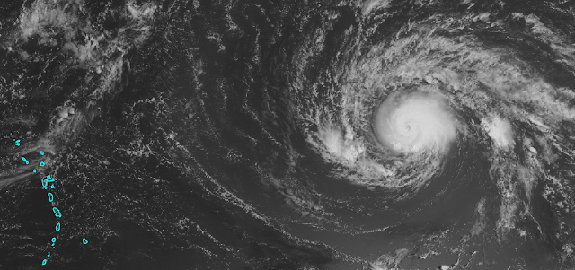
Regional satellite image with Hurricane Irma on the right and the Lesser Antilles on the left. (NASA)
As of early Saturday morning, Irma was a Category 2 hurricane packing 110 mph winds.  It is centered about 1300 miles east of the Lesser Antilles and tracking toward the west at 14 mph.  It is forecast to maintain a general westward motion through early next week then gradually turn toward to the northwest, hopefully before reaching the Leeward Islands.


The National Hurricane Center forecast brings it up to Category 4 intensity by Wednesday, but it could happen sooner.  From this point forward, it will encounter warmer and warmer ocean temperatures, and the vertical wind shear remains quite low.

The long-range model guidance has shifted slightly north again, meaning an earlier recurvature appears more likely -- though not certain.  Recurvature is when storms in the deep tropics that move generally westward start turning toward the north and the mid-latitudes.

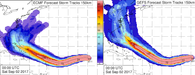
Both the European and the U.S. global models and their ensembles have significantly backed off on the threat of this storm entering the Caribbean and the Gulf of Mexico, shifting the highest probabilities toward the U.S. east coast or offshore.

Ensemble-based track probabilities out to 10 days from the ECMWF (left) and GFS (right). (A. Brammer, UAlbany)
It is absolutely too soon to place much weight on these projections right now, but there is decent inter-model agreement through the next four days.  Beyond that, the spread increases, with some heading toward the Bahamas and some up toward Bermuda.

For the U.S. east coast, **IF** the storm were to head that direction, the Sep 9-11 timeframe is the most likely as of now for landfall or a close encounter, with options ranging from south Florida (earlier in that window) to New England (later in that window).  Early next week, the Leeward Islands and Puerto Rico could be affected, then the Bahamas, the entire U.S. east coast, and Bermuda should be watching this as the days go on, and to take care of routine hurricane preparedness tasks now, before it's urgent.

You can always find the most recent NHC forecast at http://www.nhc.noaa.gov/