28 September 2023

Tropical Storms Philippe and Rina lurking in the deep tropics

Tropical Depression 17 formed on Saturday morning and was upgraded to Tropical Storm Philippe shortly afterward... and Tropical Storm Rina just formed on Thursday morning.  Both are located east of the Lesser Antilles and most likely will not affect land.  They are rather close together and in this satellite loop, it's even hard to tell them apart!  (Philippe is west of Rina)


Philippe has been hovering as a mid-range tropical storm all week, and its future is very interesting and uncertain... much more than normal.  This example is from the American global model (GFS) ensemble and is representative of the spread we're seeing in the other models.  One cluster dissipates the storm or at least keeps it weak as it heads west toward the Caribbean, while another cluster stalls, turns north, and becomes a strong hurricane.  In a few of the scenarios, this could be a close call for the extreme northeast Caribbean islands, so certainly something to pay close attention to there.  The NHC forecast is a hybrid of these outcomes: their forecast takes it west, then turning north well before reaching the islands, but keeping the intensity steady as a weak tropical storm. 


Tropical Storm Rina is located just 650 miles east of Philippe and is not expected to strengthen much.  It is the 18th named storm of the season... keep in mind the climatological average number of named storms in an entire season is 14.  There are a couple reasons for its modest intensity outlook: the proximity to Philippe and increasing vertical wind shear.


The Accumulated Cyclone Energy, or ACE, is at about 132% of average for the date, and 99% of an average full-season's total. Impressively, today is the 40th consecutive day of ACE accrual... the activity has been nonstop from Emily through Rina!


Although there are no other features of interest out there to monitor yet, the next couple of names on the list are Sean and Tammy.  As we head into October, activity from Africa begins to dwindle, and we start looking to the western Caribbean and Gulf of Mexico for formation areas.  The ocean temperature in these areas is also very warm compared to normal for this time of year, so not only does that give incipient storms a nudge, the area of "favorable" warm water is larger than normal too.


21 September 2023

Monitoring two new disturbances as Nigel exits the scene

Activity in the Atlantic has been relatively uneventful for the middle of September, so since my previous post on Friday, Lee did of course make landfall in Nova Scotia, Margot dissipated, and Nigel became a hurricane.  Today, Nigel is heading for colder water and won't be around much longer, but there are two areas of interest to keep an eye on.  The next two names are Ophelia and Philippe.


I'll start with Nigel.  It was upgraded to a hurricane on Monday morning and tracked north through the middle of the Atlantic.  It reached Category 2 intensity for a while late Tuesday into Wednesday, but is now a Category 1 hurricane again, and expected to become an extratropical cyclone by Friday morning as it heads toward Iceland... two weeks after leaving the African coast.


The first area of interest to watch for development is a low pressure that is beginning to form along an old stalled-out cold front.  It's centered east of the Florida peninsula and has been designated as Potential Tropical Cyclone 16 by NHC on Thursday morning.  That means it still hasn't formed, but is expected to and warrants some tropical storm warnings.


It already has characteristics that are more subtropical than tropical, but either way, it would get named and NHC will issue advisories and forecast products for it.  The forecast brings it north to a landfall in North Carolina on Saturday morning as a (sub)tropical storm. Tropical storm force winds will likely arrive in eastern NC on Friday evening.  You can find the full suite of the latest forecast products at https://www.nhc.noaa.gov/graphics_at1.shtml?start#contents

Parts of North Carolina, Virginia, and Maryland could see 2-4 feet of the storm surge from this over the weekend, and the threat of flooding rain is increasing from North Carolina up into New England.


Much further east is an easterly wave that left the African coast on Tuesday.  It's located just southwest of Cabo Verde and is expected to track generally west-northwest for the next week or so, then its future path becomes harder to predict.


This is not an Invest yet, so we are limited to global models and their ensembles for guidance.  The two skillful ones we typically look at are the American (GFS) and European (ECMWF).  These two images below show the tracks from the GFS (top) and ECMWF (bottom) ensembles, ending next Friday evening. Although both of them are pretty consistent in bringing it up to hurricane intensity by Tuesday-ish, and both of them have a general tendency to turn it north by the time gets to 60°W-ish, the GFS ensemble does have more members that show a hurricane clipping the northeast Caribbean islands.  This is something we need to watch closely, because if that route starts looking more likely, it makes the northward turn less likely which has implications in the following days.


Again, the next two names are Ophelia and Philippe and it's not clear yet which of these two systems will become a tropical (or subtropical) cyclone first.

The Accumulated Cyclone Energy, ACE, is about 142% of average for the date.

15 September 2023

Lee heading for Canada, Margot weakening, Nigel on the horizon

Since my update on Tuesday, Lee and Margot have "behaved" as forecast: Lee turned north, weakened, passed west of Bermuda, and is headed for Nova Scotia.  Margot maintained Category 1 hurricane intensity but just dropped back down to a tropical storm early Friday morning. Finally, Invest 97L became Tropical Depression 15 on Friday morning and will be named Nigel once it reaches tropical storm intensity.  On the satellite loop below, Lee is in the upper left, Margot is in the upper right, and TD15 is in the bottom middle.


Lee is now a Category 1 hurricane and a very large one at that.  Tropical storm winds extend as far as 320 miles from the center, and hurricane winds extend as far as 105 miles from the center. A storm surge of 1-3 feet is possible along much of the New England coast.

It is forecast to make landfall in western Nova Scotia midday Saturday though strong winds will arrive before that... it could be an upper-end tropical storm or Category 1 hurricane, and possibly no longer technically be classified as a tropical cyclone, but that does not change the expected impacts.  This process is called "extratropical transition", and it involves changes in the dynamic and thermodynamic structure and properties of the cyclone.  Extratropical cyclones can also be very intense and impactful (remember Sandy 2012?).


Margot could be around for a while longer, generally maintaining tropical storm intensity.  It found itself in an area of weak steering flow and is just circling around west of the Azores.  Even if it eventually reaches the Azores sometime in the middle of next week, it should not be too much of a concern.


Elsewhere, the Invest 97L and 98L merger happened and has been carried as just 97L... at 11am Eastern on Friday it was upgraded to Tropical Depression 15 and it's quite close to reaching tropical storm status. The next name is Nigel which is a new name on the list, replacing Nate from the 2017 season. 


TD15 is located about 1200 miles east of the Lesser Antilles in the deep tropical Atlantic.  There is strong agreement among the models that TD15/Nigel will continue tracking to the northwest for the next five days or so, then turn north by the time it reaches about 60°W.  The models also agree on it becoming a strong storm -- very likely a hurricane by Monday.


The Accumulated Cyclone Energy (ACE) is at about 148% of average for the date and is the highest value for the date since 2017, then 2008 before that.  In other words, pretty exceptional.


12 September 2023

Hurricane Lee about to turn north, widespread impacts expected in US and Canada

Lee is still major hurricane, and has been since Thursday afternoon ("major" is conventionally defined to be Category 3+).  It's moving toward the west-northwest but the long-awaited north turn should commence later today or early Wednesday.


It's likely going to bring tropical storm conditions to Bermuda on Thursday, then to eastern New England and eastern Canada on Saturday.  It's too soon to know exactly where the center of the storm will go, but it will be a large storm with a broad wind field... areas far from the center will experience impacts.  That said, the model consensus track has been unwavering with a landfall point near western Nova Scotia on Saturday night into Sunday morning.


The U.S. east coast, Nova Scotia, and Newfoundland are going to experience some significant impacts from Lee in the coming few days: primarily coastal flooding from storm surge.  To add to the flooding, tides are amplified surrounding Thursday's new moon. The animation below shows the predicted "significant wave height" from the GFS wave model, out to next Tuesday morning.  With the new moon's assistance, this multi-day onshore swell energy is going to create big problems from Florida to Newfoundland.


Margot was upgraded to the season's fifth hurricane on Monday afternoon but it not going to affect land. It's intensifying and is nearly a Category 2 hurricane as of Tuesday morning. It will continue heading north into cooler waters and gradually dissipate in a week or so.


There was a little bit of a traffic jam leaving Africa, and two easterly waves (Invests 97L and 98L) are very close to each other and they might end up merging.  This sloppy beginning could still produce a tropical cyclone, and the model guidance supports that.  NHC is giving it a 70% chance of development within a week.  The GFS ensemble track forecast out to next Tuesday morning is shown below to give a sense of the spread with this so far.

It is certainly something to keep an eye on... should it become a tropical storm, the next name on this list is Nigel.  Nigel is a new name on the list, replacing Nate from the 2017 season.


Climatologically, September 12 is the halfway point of the season in terms of Accumulated Cyclone Energy (ACE).  Through today's date, this year's ACE is the highest since 2017, and actually exceeds the full-season total of many recent years (2015, 2014, 2013, 2009, 2007, 2006, 2002, etc).  It's at 143% of average for the date, and 73% of the full-season average value.


09 September 2023

Watching Hurricane Lee and TS Margot heading into peak week of hurricane season

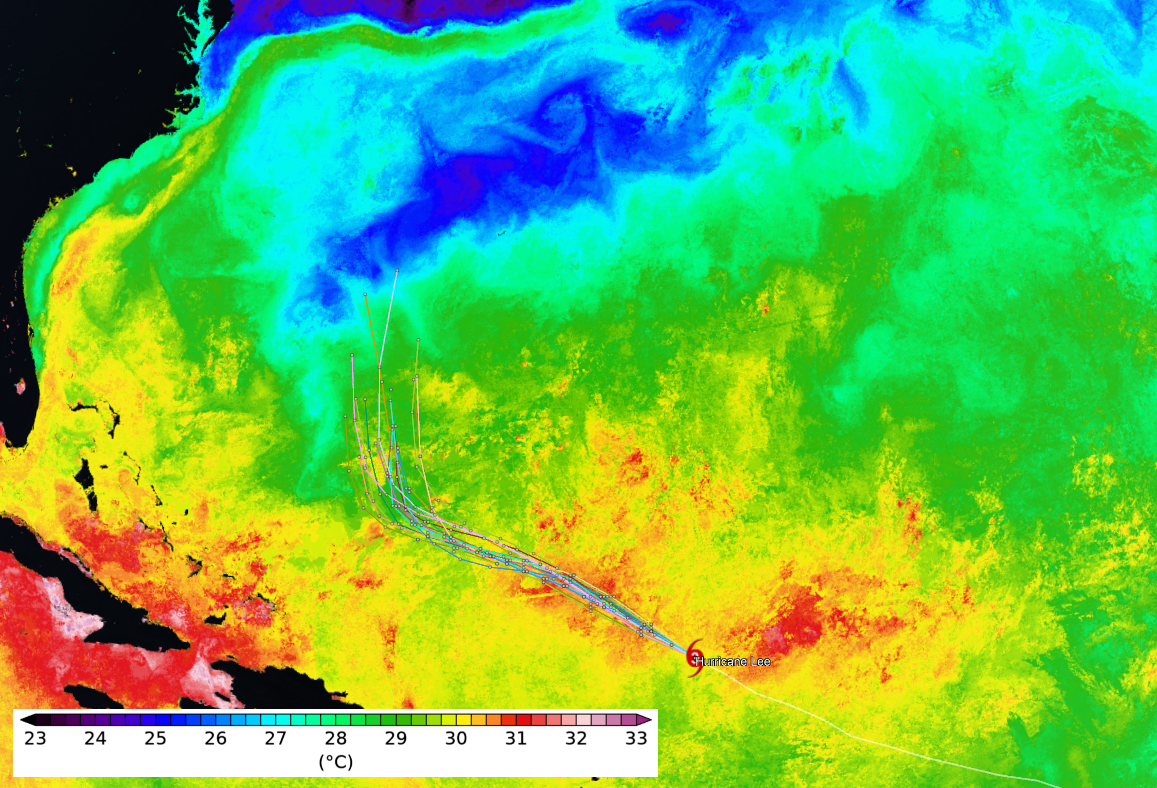
Unfortunately, I did not get a chance to write a post on Friday... and the reason it's unfortunate is that a very rare explosive intensification had just concluded with Hurricane Lee.  Only two other storms intensified more rapidly than Lee did in the Atlantic: Wilma 2005 and Felix 2007.  The sustained winds increased by 85mph in a day, going from a low-end Category 1 hurricane (80mph) to a Category 5 hurricane (165mph).  There were frequent aircraft reconnaissance flights into the storm that sampled the intensity very well.

For posterity, the infrared satellite animation below spans the 24 hours from Thursday-Friday 5am EDT.  Another interesting and related bit of weather trivia came to life on Friday: 2023 is now the first year in recorded history in which a Category 5 hurricane (or equivalent) occurred in every tropical cyclone basin in the world... see WaPo's Capital Weather Gang article for details.  That's also rather remarkable.


In the meantime, some moderate wind shear and eyewall replacement cycles have weakened the storm a bit, though it's still a formidable major hurricane with 115 mph peak sustained winds.  As of Saturday at 5pm EDT, Lee is a Category 3 hurricane located north of the Leeward Islands and is forecast to regain Category 4 intensity on Sunday and Monday.  The visible satellite below brings us back to current time (Saturday afternoon):


The model guidance is solidly indicating that Lee will turn north on Wednesday, and the NHC forecast reflects that.  It should remain a Category 3-4 hurricane through at least the next five days.


Then, on Friday-ish, Lee will pass over the cold wake that Hurricane Franklin left behind... and it's noticeably colder than the water it's been accustomed to so there is little doubt the hurricane will respond accordingly.  This map shows today's sea surface temperature analysis with some model forecast tracks overlaid.  Tranklin's cold wake is the blue streak that the tracks approach at the end of the forecast period.


Further east, and also on Friday, Tropical Depression 14 became Tropical Storm Margot, the 14th named storm of the season.  It is located in the middle of the tropical Atlantic, far from land, and its forecast track keeps it far from land.  It's expected to become the season's fifth hurricane by the middle of next week.


Not surprisingly, the Accumulated Cyclone Energy (ACE) got a big boost from Lee and will for the next week or so.  As of today, it's roughly 130% of average for the date.  Climatologically, the halfway mark of the season in terms of ACE is coming up on September 12.


As a side note, September 10 is the 6-year anniversary of Hurricane Irma's landfall in Florida... if you're interested in that storm's history, please visit https://bmcnoldy.earth.miami.edu/tropics/irma17/history.html

07 September 2023

Tropical Depression 14 joins Category 2 Hurricane Lee

As expected, Lee is rapidly intensifying east of the Leeward Islands and is now officially forecast to be a Category 5 hurricane on Friday-Saturday.  Additionally, the easterly wave I mentioned yesterday that was near Cabo Verde has been upgraded to Tropical Depression 14 and is likely to become the season's fifth hurricane this weekend.  Its name will be Margot.


As I wrote in yesterday's post, a long-track major hurricane is a certainty.  There is significant agreement among the models that Lee will turn north next Tuesday-Wednesday somewhere between 65-70°W.  But a few stragglers from various ensembles and several model cycles stubbornly do not follow the pack and fail to make the north turn.  The map below shows the tracks from the Thursday morning GFS model ensemble -- the forecast period of these tracks ends next Friday morning (Sept 15th).


Former-Invest 96L is now Tropical Depression 14 and it's also getting its act together quickly; it'll probably be the 14th named storm later today or early Friday.   The next name is Margot, which is a new name on this list... it replaced Maria after its retirement in 2017.The model guidance indicates a turn to the north by the time it reaches about 45°W, and the NHC forecast closely follows that.  It has a shot at reaching Category 3 intensity in 4-5 days but will not affect land.


Climatologically (1991-2020), an entire season has 14 named storms, but we're not even to the halfway point of this season yet in terms of ACE (that's coming up on September 12). And just as a refresher, the 2022 hurricane season ended with 14 named storms.


06 September 2023

Lee forms and expected to become major hurricane by the weekend

A well-organized easterly wave left the African continent last Friday (Sept 1) and was upgraded to Tropical Depression 13 and then again to Tropical Storm Lee on Tuesday (Sept 5).  As of midday Wednesday it is nearly a hurricane and is expected to become the season's 4th hurricane later today.


Lee is centered about 1200 miles east of the Lesser Antilles and is moving toward the west-northwest at 14 mph.  As of now, the model guidance and the NHC forecast keep the center of the storm north of the Leeward Islands this weekend.  Within 3-4 days, there is model guidance indicating that Lee could become a Category 5 hurricane, an intensity only reached by 2-3% of all tropical cyclones in the Atlantic.


In the longer term (beyond five days), there is more spread in the guidance... as one would expect.  The majority of ensemble members turn Lee to the north by the time it reaches the longitude of Puerto Rico or Hispaniola.  But some, primarily from the UKMET ensemble, miss the turn and keep it tracking toward the west-northwest.  This split would occur late next week, so there is plenty of time to see how these evolve and what land areas should be on higher alert.  It's also worth mentioning that the ensemble members that miss the north turn tend to have weaker storms that are not as likely to be steered by the approaching trough that will come from the eastern U.S.


Elsewhere in the basin, another easterly wave just south of Cabo Verde has high chances of development in the coming week, and is tagged as Invest 96L.  The next name on the list is Margot, a replacement for Maria which was retired after the 2017 season.


The seasonal track map through today is shown below, with the storms' peak intensity, minimum central pressure, and ACE (Accumulated Cyclone Energy) contribution listed on the right side.  Perhaps because of El Niño's suppressing influence on the tropical Atlantic, it's interesting to note that only 30% of the season's ACE has actually come from the tropics (equatorward of 23.5°N) -- more than 2/3 of the activity has occurred in the subtropics. 


On the topic of ACE, it's at about 115% of average for the date, but there's no doubt that Lee will provide a huge surge to the tally in the coming 10+ days.