28 October 2011

Rina passes over Cancun, weakens to a Depression

Since yesterday's update, Rina became even less organized and lost what little deep convection it had.  This was well-timed for Mexico though, since Rina made landfall on Playa del Carmen (the mainland city directly west of Cozumel) at 03Z today (late Thursday night for them) then passed over Cancun.  Its 9-hour traverse over land, combined with the increasingly hostile environment, was responsible for the downgrade to a 30kt Depression at 15Z today.  All that remains is a tiny harmless low-level swirl just off the northeastern tip of the Yucatan peninsula.  For a very Wilma-like origin and track, thankfully the intensity didn't follow suit.

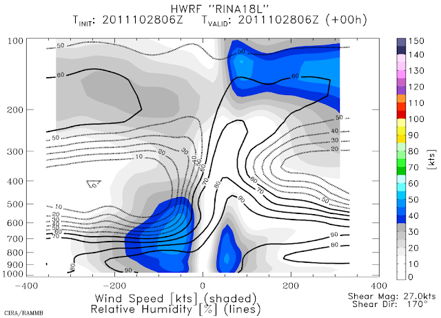
The image below shows a vertical cross-section taken along the shear vector (southerly) from one of the regional hurricane models (HWRF's 06Z analysis).  The fields shown on there are the wind speed (shaded) and relative humidity (lines).  It's easy to see how weak and shallow the vortex is, and the intrusion and overriding of very dry air... the analyzed shear is 27kts too.  This is not an environment that a storm can redevelop in.


Rina is forecast to lose its remaining tropical characteristics and degenerate to a remnant low very shortly, meandering around in the same vicinity due to weak steering flow.

Please visit my tropical Atlantic headquarters.
Subscribe to get these updates emailed to you.

27 October 2011

Rina downgraded to Tropical Storm

In a battle against increasing vertical shear, Rina was downgraded to a 60kt tropical storm at 15Z today.  The center is located just south of Cozumel and heading NNW at 5kts. You can also track it on Cancun's radar: http://smn.cna.gob.mx/radares/cancun/cancun.php


Now that it has weakened and the convective area associated with it has shrunk drastically, it is steered by different layers of the atmosphere.  Deeper systems are steered by a deeper layer, and weaker/shallower systems are steered by a lower and shallower layer.  That said, the forecast track now calls for Rina to stall in place, just meandering around in a loop waiting for some stronger steering flow to pick it up.  The track plot in the map below shows forecasts from 3 dynamical models, and the NHC forecast is basically an average of these.  The thin light lines are prior 00Z forecasts and can be ignored.  The official intensity forecast also follows the model guidance closely: gradual weakening over the next several days.


Please visit my tropical Atlantic headquarters.
Subscribe to get these updates emailed to you.

25 October 2011

Rina nearly a major hurricane

In the past day, Rina has intensified to a 95kt hurricane, with a high likelihood of reaching 100kts... it would become the season's 4th major hurricane.  Visually, it has become a beautiful symmetric storm, with delicate outflow cirrus expanding uniformly away from the center.

It has another couple of days to enjoy a low-shear environment, then as it heads further north toward Cuba, the upper-level winds become quite a bit more hostile.  But in the meantime, the ocean below it is extremely warm not just at the surface, but is warm quite deep too (that minimizes upwelling effects that slow-moving systems are prone to).  The map below shows the depth of the 26C water... Rina's current location has some of the deepest warm water in the entire Atlantic basin.


The forecast is still quite tricky because of the weak steering environment.  In the next few days, it should continue its slow crawl to the N-NW, but after that, its future depends on whether or not it gets "picked up" by a passing mid-latitude trough.  If it does, it will make a turn to the NE and head for Cuba and then Florida... if it doesn't, it should meander slowly to the west or even stay approximately stationary.
Basically... Mexico, Cuba, and Florida should all be watching this very closely.
Some additional strengthening is still possible, and for at least the next day, there's no reason Rina can't strengthen quite a bit.


Please visit my tropical Atlantic headquarters.
Subscribe to get these updates emailed to you.

24 October 2011

Rina becomes season's 6th hurricane

In what was a somewhat expected rapid intensification (based on satellite presentation), Rina was upgraded to a 65kt hurricane at 18Z today.  The central pressure is 991mb, and it's still crawling north at 4kts.  And again, given its appearance and environment, it's quite likely that additional intensification will occur, perhaps reaching Category 3 status by tomorrow.  In the visible satellite image below, you can already see an eye forming:

Full zoop (zoomed out):
http://rammb.cira.colostate.edu/ramsdis/online/loop_640.asp?product=tropical_ge_4km_visir2_floater_2

Please visit my tropical Atlantic headquarters.
Subscribe to get these updates emailed to you.

Rina forms in western Caribbean

The disturbance off the coast of Nicaragua that I mentioned in Friday's update has gotten much better organized... and on Sunday at 21Z was upgraded to TD18, then six hours later, to TS Rina.  This is the 17th named storm of the season; climatologically by this date we have had just ten named storms.

At 15Z today, Tropical Storm Rina's intensity is 40kts, with a 1001mb central pressure... and an appearance that suggests some hefty intensification can be expected.  It's currently located north of the eastern tip of Honduras, and the forecast track calls for a very slow crawl toward the northern tip of the Yucatan peninsula.  The majority of models bring this system up to hurricane intensity by Wednesday.


This time of year, this location, and this track forecast are very similar to Wilma (2005)... but so far, we aren't dealing with a Category 5 hurricane.  At Rina's position, Wilma was a Category 5 storm six years and five days ago.  This map below is for Wilma... NOT Rina:


There's also a disturbance in the far eastern Caribbean that is worth keeping an eye on...


Please visit my tropical Atlantic headquarters.
Subscribe to get these updates emailed to you.

21 October 2011

Disturbance festering in southwestern Caribbean

For nearly a week now, there has been an area of disturbed weather in the extreme southwestern Caribbean.  It's origins appear to be a combination of a  tail of a cold front and the ambient monsoon depression.  There is a 1010mb Low associated with the disturbance, and the low-level center is approximately 200 miles off the Nicaraguan coast.

The system is in a low-shear environment, and the shear is expected to remain below 20kts for at least the next several days.  The SST is and will be nearly 30C.  There is not yet a lot of model guidance for this, but the global models indicate that it will develop and VERY slowly crawl northward toward Cuba as it intensifies.  Certainly something to keep a very close eye on, since the western Caribbean during time of year has birthed some infamous Category 5 hurricanes: Hattie 1961, Mitch 1998, and Wilma 2005.  The plot below shows the tracks of 11 storms that formed in October in the western Caribbean and became major hurricanes.  Note the relatively tight track pattern... north toward Cuba and Florida (Hattie, Mitch, and Wilma are the 3 that first went west before recurving/dissipating).  If named, the next name on the list is Rina (replaces Rita from 2005).


Please visit my tropical Atlantic headquarters.
Subscribe to get these updates emailed to you.

06 October 2011

Philippe becomes a hurricane after 12 days

The first advisory was written on Philippe on Sept 24th, and since then, it has fluctuated in intensity from 35-60kts, but never dropped to a depression, and never made it to a hurricane... until this morning.  At 15Z today, Philippe's estimated intensity was 70kts and 985mb, making it the 5th hurricane of the season.  It's located about 415 miles southeast of Bermuda and moving NNE at 8kts.

However, this is also its last gasp as a tropical system.  Over the next couple of days, it will encounter SSTs nearing 20C and vertical shear up to 50kts and it will become an extratropical storm then finally merge with its mid-latitude trough.

To support the 70kt hurricane classification, the microwave image below (from NRL in Monterey CA... at 1023Z this morning) shows what appears to be an eye and eyewall, and definitely some strong tightly-curved rainbands.  The latest visible and infrared images are indeed showing a slightly clearing eye... I included an enhanced visible image from 1445Z below the microwave image so you don't just have to take my work for it!


Please visit my tropical Atlantic headquarters.

03 October 2011

Ophelia turns extratropical, Philippe still a TS

At 15Z today, the final advisory was written for Ophelia... 18 days after it left the African coast and 13 days after it was first classified as a tropical storm.  Over the weekend, the storm reached a peak intensity of 120kts and 940mb (Category 4) as it passed 140 miles east of Bermuda.  It's presently a 50kt extratropical cyclone and just passed over Newfoundland (exactly the same landfall location as Maria 17 days ago!).


Early Saturday morning, it did indeed pass very close (just 5.4 miles west!!!) to Buoy 41049 as I mentioned.  The buoy reported 40ft waves, wind gusts up to 100kts, and a pressure of 952mb.  The plot below was made using hourly data from the buoy:

Philippe is still hanging around, and is still a tropical storm.  Surprisingly though, on Sunday morning, it was nearly a hurricane!  It reached an intensity of 60kts and 993mb, but has since weakened again to 55kts.


It is forecast to continue westward for another 24-36 hours, then recurve abruptly into the north central Atlantic.

Please visit my tropical Atlantic headquarters.

30 September 2011

Ophelia now a major hurricane

Against all odds, the storm that was not even a Depression three days ago is now a 100kt major hurricane... the 3rd major hurricane of the season.  Since the 27th at 21Z when Ophelia regained Depression status, the maximum winds increased 75kts and the central pressure fell 48mb.  More impressively, we can narrow the time window down to the past 12 hours, when the winds increased by 25kts and the pressure fell 19mb.

This rapid intensification was not anticipated by dynamical models, statistical models, or human forecasters, and goes to show how little we still know about what makes these storms tick.  One run sticks out, which suggests it was more serendipitous than skillful... HWRF's 18Z run on Sep 27th was fairly accurate:

Ophelia is now forecast to maintain Category 3 intensity for another day or so, then gradually weaken and become extratropical by early next week as it gets whisked into the north central Atlantic by a strong mid-latitude trough.  Something to keep an eye on is Buoy 41049, which should get a near hit from Ophelia on Saturday afternoon: http://www.ndbc.noaa.gov/station_page.php?station=41049.  The winds are already on the rise there, the pressure is falling, and the significant wave height is up to 10 feet and increasing rapidly.

Philippe hasn't been so fortunate.  Still a 45kt tropical storm, it is battling relentless vertical shear, and will continue to do so for several more days.

In the plot below, you can see the track forecasts taking it generally westward over the next 5 days, and the shear forecast highlighting an unpleasant week for Philippe.  The official intensity forecast is in line with the statistical models on that plot (LGEM, DSHP, SPC3), and weakens the storm to a Depression by the end of the weekend.


Please visit my tropical Atlantic headquarters.

29 September 2011

Fourth hurricane of the season

At 21Z today, Ophelia was upgraded to a 65kt hurricane, the 4th of the season.  This is still a record low number of hurricanes for having 16 named storms though.  Looking back through the records, any season with 16+ named storms had at least 7 hurricanes.


The storm intensity guidance is from satellite estimates, since there aren't any aircraft in it, and it's not too close to any buoys.  The central pressure is down to 987mb, with a forecast for additional strengthening over the next couple of days.

Please visit my tropical Atlantic headquarters.
Ophelia nearly a hurricane

The easterly wave that exited the African coast on September 16 became TS Ophelia on Sep 21, then on the 25th was so weak that it wasn't even classified as a Depression.  A couple days later, it regained Depression status, then yesterday it regained TS status, and today, after this tremendous comeback, it is almost the season's 4th hurricane!  The images on this page allow you to easily track the appearance of this system over the past week: http://einstein.atmos.colostate.edu/~mcnoldy/tropics/hovmoller/epac_carib1/

At 15Z this morning, Ophelia is a 60kt TS with 991mb central pressure.  The microwave image below shows quite clearly that the storm has formed an eyewall, though the eye hasn't cleared out yet in infrared imagery.


The forecast is for some additional strengthening over the next couple of days as it heads north toward Bermuda.  Then as it comes under the influence of a mid-latitude trough, the shear will increase, and as it enters the north-central Atlantic, the SSTs will decrease.  Together, these effects will transform Ophelia into an extratropical cyclone within 4-5 days.

Moving on to Philippe... not much has changed.  The storm is still embedded in a strong vertical shear environment, so the deep convection associated with the Low is displaced completely to the northeast of the surface circulation.  At 15Z, the intensity estimate is 40kts and 1005mb... located about 1240 miles west of the Cape Verde islands.
The forecast is looking more interesting with time.  A large-scale ridge is expected to move back over the central Atlantic, which would steer eastern Atlantic systems more to the west (the current trough in place has been pulling everything north).  So despite the shear remaining fairly high during the period, the SSTs will at least be warm, and Philippe should be several degrees north of the Leeward Islands by the middle of next week.

Please visit my tropical Atlantic headquarters.

28 September 2011

Ophelia makes a comeback, and Philippe struggles

Since my last update on Monday, the remnants of Ophelia made a comeback.  The vertical shear decreased a bit more than expected, and the storm was surprisingly quick to take advantage of the improved environment.  It was upgraded to a Depression on Tuesday afternoon, and at 15Z this morning was upgraded again back to a Tropical Storm.  Though it's still in nearly 20kts of shear, convection has remained much closer to the center than it was a couple of days ago.  The latest intensity is 45kts and 1002mb.

You can view a radar loop of Ophelia from Guadeloupe at http://einstein.atmos.colostate.edu/~mcnoldy/tropics/ophelia11/Ophelia_27-28Sep11.gif
Although it's currently meandering very slowly, it is forecast to accelerate to the north within a day, and like Maria, reach hurricane intensity for the first time thanks to baroclinic enhancement as it interacts with a mid-latitude trough.  It should remain safely east of Bermuda when it passes by there on Saturday.

TS Philippe has a very similar appearance on satellite, but is a little weaker: a 35kt storm with 1006mb central pressure.  The forecast varies greatly depending on whether you're looking at a statistical models or dynamical models.  The official forecast agrees with the statistical models (LGEM, SHIPS, etc), by the way.


Please visit my tropical Atlantic headquarters.

26 September 2011

Ophelia dissipates and Philippe forms

Since my last update on Friday, Ophelia succumbed to the strong vertical shear and lost its tropical characteristics... namely, co-located persistent deep convection.  The final advisory was written on Sunday afternoon, and it's currently being tracked as a remnant low with a slight chance of regeneration... located northeast of the Leeward Islands.

Also since Friday, the disturbance I mentioned in the far eastern Atlantic was upgraded to TD17 shortly after my update was sent out, then upgraded again to TS Philippe on Saturday afternoon.  Philippe is the 16th named storm of the season... climatologically we would have just 8 named storms by this date.  Amazingly, 2011 is on par with the hyperactive 2005 season (in 2005 we were at the 17th named storm by this date).  As of this morning at 15Z, Philippe is a 50kt tropical storm located 600 miles west of the Cape Verde islands.

Philippe is also struggling with fairly strong vertical shear, as well as moderate SSTs (27C)... it should continue to maintain TS intensity as it recurves to the north in the coming days.  The 500mb chart below shows a deep trough in the central Atlantic that is responsible for recurving this storm so quickly.


Please visit my tropical Atlantic headquarters.

23 September 2011

Ophelia still struggling, new disturbance in far eastern Atlantic

Over the past couple of days since my last update, not much has changed with TS Ophelia... the storm reached 55kt intensity, but has been plagued by very strong vertical shear.  At 15Z today, it's down to a generous 35kts, with a forecast for additional weakening.  In the satellite image below, you can see the exposed surface circulation near 15N 53W with a convective blowup to the north, but the bulk of the convection displaced far to the east.  It's in about 20-25kts of southwesterly shear, and over the next 5 days, that is not expected to let up at all.

As you can see from the plot below, the models have backed off significantly on their intensity forecasts, and their high-shear environments all agree in the near term (GFS is quite a bit larger several days out, and that is the model that the DSHP and LGEM intensity models are based on).


Elsewhere, a fresh easterly wave exited the African coast yesterday and is presently south of the Cape Verde islands.  This wave was born over the Ethiopian Highlands 8 days ago and has a history over the past 3-4 days of being convectively active.  It appears likely that this system will be our next named storm: Philippe.


Please visit my tropical Atlantic headquarters.

21 September 2011

TS Ophelia forms

[This is the second and final update being sent to both the old and new mailing lists.  Check to make sure you are receiving this with tropatlan@googlegroups.com in the "To" field.  There are still quite a few people who have not migrated to the new list.  If you need any assistance or have questions, please ask.]

The easterly wave that exited the African coast on Sep 16 was upgraded to Tropical Storm Ophelia at 03Z today.  This is the 15th named storm of the season... climatologically by this date we would have just 7 named storms!


A fairly recent ASCAT overpass from 12Z shows a nice closed surface circulation with TS-force winds in the north half (ASCAT is a satellite-based microwave scatterometer which is able to retrieve surface wind speed and direction over water by detecting the surface roughness caused by winds disturbing the ocean's surface).


At 15Z this morning, Ophelia's intensity was estimated at 50kts with a minimum central pressure of 1005mb.  It's located about 1100 miles east of the Lesser Antilles and tracking W at 14kts.  It's being sheared, so the intensification has likely leveled off and it will continue to the W-WNW over the next several days as a TS.  The official forecast places it just north of Puerto Rico in 5 days as a TS, and the majority of model guidance supports that scenario.

Please visit my tropical Atlantic headquarters.

19 September 2011

New disturbance in eastern Atlantic

[This message is the first being sent to both the old and the new email lists.  I apologize for duplicate mailings, but I want to give everyone a chance to migrate and accept the invitation to the new Google Groups list.  If you have not yet accepted the invitation I sent on Friday (there is a link to click in that message... the subject was "Google Groups Invitation: Tropical Atlantic Update"), you will stop receiving these updates once I discontinue the old list.  The old distribution address was tropical@atmos.colostate.edu, and the new address is tropatlan@googlegroups.com.  Please check with me if you have any questions or problems!]


Over the past week or so, 3 easterly waves left the African coast.  But rather than making their way westward one after the other, they have begun to accumulate in a weak-steering region between 35-40W.  There's some evidence of this if you look at the time series of infrared images over the deep tropics: http://einstein.atmos.colostate.edu/~mcnoldy/tropics/hovmoller/atlantic/   In this view, the newest image is on top, and then you look back 12 hours every slice as you go down the page.  This allows you to track persistent features (such as African easterly waves) for many days simply by looking at their convective signature!  The visible satellite below shows the appearance of this disturbance as of this writing, with the surface center location marked by a red dot.  The estimated intensity is 25kts and 1008mb, and it's very close to becoming a Depression (TD16).  The next name on the list is Ophelia.

The plot below shows the past, present, and forecast intensity, track, shear, SST, and mid-level humidity.  The important thing to take away from it is that significant development of this is not expected in the near future, mostly because the vertical shear will be rather high.


Please visit my tropical Atlantic headquarters.

16 September 2011

Maria becomes season's third hurricane

After 9 days in the deep tropics since it was first classified as a Depression, Maria was upgraded to a hurricane at 21Z yesterday... making it the 3rd of the season (after Irene and Katia).  The extratropical transition is underway, and though it won't be classified as a hurricane much longer, it will remain a powerful extratropical cyclone with hurricane-force winds as it heads across the northern Atlantic toward Greenland and Iceland.  As of 15Z today, it is a 65kt hurricane with a 983mb central pressure... located just offshore of Newfoundland and racing NE at 45kts.

You can follow Maria on radar (until it zips out of view anyway) at http://www.weatheroffice.gc.ca/radar/index_e.html?id=WTP

Also, we've gotten lucky again with a buoy... Buoy 44251 is presently just 34 miles west of the center, and is reporting the following as of this writing (you can follow up later and see the full trace at http://www.ndbc.noaa.gov/station_page.php?station=44251):


Please visit my tropical Atlantic headquarters.

14 September 2011

Maria strengthens slightly

Over the past two days since my last update, Maria has barely maintained intensity in the 45-50kt range, due to the strong vertical shear.  Since Tuesday morning, the central pressure fell 5 mb... the only sign of vigor it has shown lately.  At 15Z today, the intensity is 50kts and 1001mb.  The low-level center (marked by the red dot on the image below) is still on the far fringe of the deep convection in the face of 15kt shear.

At about 06Z today, Maria passed just 20 miles west of Buoy 41046, and the buoy reported a surface pressure of 1004.5mb, along with sustained winds of 33kts, gusts to 43kts, and a significant wave height of 18 feet.  The wind and pressure trace also indicates a fairly weakly-organized core, with the pressure minimum coinciding with a tiny wind minimum and surrounded closely by wind maxima.  Quite a different look than the plot I showed from Katia's passage over Buoy 41048 six days ago!

Much like Katia, Maria is about to encounter a strong mid-latitude trough... and with that comes some baroclinic enhancement and an eventual extratropical transition.  So, in the coming couple of days, the storm could approach hurricane intensity even as the shear skyrockets and the SSTs plummet.  It will recurve between Bermuda and the US, with the closest approach to Bermuda occurring Thursday morning.

Please visit my tropical Atlantic headquarters.

12 September 2011

Nate makes landfall, Maria still a TS

Nate never made it to a hurricane, but that fits with the rest of the season.... only 2 of the 14 named storms have become hurricanes.  That's just 14% compared to the climatological 50-60%.  However, in terms of named storms, 2011 is just 1 behind the mega-season of 2005... by this date in 2005, we were on the 15th storm, and this year, we're on the 14th.  Tropical Storm Nate made landfall at about 1730Z on Sunday by Poza Rica.  The satellite image below is from the approximate time of landfall, and the full radar loop from Alvarado can be found here: http://einstein.atmos.colostate.edu/~mcnoldy/tropics/radar/index.html#nate11


Maria has been battling relentless vertical shear.  Now up to 30kts, the shear has displaced Maria's deep convection far to the east of the low-level circulation, as you can see clearly in the visible satellite image below (the surface center is near 21.7N 67.2W in this image). 
The intensity has been holding at 50kts for the past 30 hours, and the track has also been steady at WNW at around 8kts.  It is forecast to begin recurving to the north shortly, well before reaching the US, then pass just west of Bermuda on Wednesday night, then zip off into the north-central Atlantic.  It's still a possibility that Maria will reach hurricane status in 48-60 hours when it briefly could be exposed to less shear, and when it begins to experience baroclinic enhancement.

Elsewhere, a large easterly wave has just exited the African coast today, and has had a history of being very active since it formed over the Ethiopian Highlands on Sep 4.  It is not organized at all yet, but the surface pressure in coastal African stations fell to about 1011mb as it passed over, and is the next feature to keep an eye on over the coming week.


Please visit my tropical Atlantic headquarters.

09 September 2011

Katia, Maria, and Nate still making waves

Katia remains a strong Category 1 hurricane with 75kt winds as it recurves into the north central Atlantic.  It's over 26C water, in about 20kts of vertical shear, and is about to begin its extratropical transition (ET).  This will be a major storm for the UK early next week.

 The baroclinic enhancement that commonly occurs with ET can keep the intensity high even amidst what we typically think of as hostile conditions.  In the next 24h, the SST will plummet to 18C and the shear will increase to about 45kts, but the storm could still pack hurricane-force winds.  ET involves losing the circular symmetric structure and becoming more frontal in nature (which implies the cyclone tilts with height rather than being vertically stacked), while at the same time transitioning from a warm-core system to a cold-core system (which implies the strongest winds move outward and upward).  Tropical cyclones have their strongest winds at the surface and close to the center, while extratropical cyclones have their strongest winds aloft and quite removed from the center.

Maria has regained a lot of deep convection, and the intensity as of 15Z today is 40kts, with a forecast for VERY slow intensification over the next 5 days as it heads WNW toward the Bahamas.  Tropical Storm warnings cover the Leeward Islands and Puerto Rico (http://www.nhc.noaa.gov/storm_graphics/AT14/refresh/AL1411W5+gif/145220W_sm.gif). The vast majority of forecast models now indicate that Maria will follow a track similar to Katia, so as of now, it appears that the US east coast could be spared another rainmaker.

Nate is organizing and wrapping up, but part of what it's wrapping up is the very dry air from Mexico and the northwestern Gulf.  The entrainment of dry air into the system has limited its intensification, but it's still a 55kt tropical storm.  It is forecast to reach hurricane status by tomorrow morning as it crawls slowly westward toward the northern Veracruz coastline in Mexico.  There are hurricane and tropical storm watches/warnings around the Bay of Campeche's perimeter: http://www.nhc.noaa.gov/storm_graphics/AT15/refresh/AL1511W5+gif/143800W_sm.gif


Finally, it's worth noting that we are in the peak of the season now... Sept 10 is climatologically when we have the most activity in the basin: http://www.nhc.noaa.gov/climo/images/peakofseason.gif


Please visit my tropical Atlantic headquarters.

08 September 2011

Katia turns north, Maria struggles, and Nate strengthens

Hurricane Katia strengthened slightly to 80kts as of 15Z today, and did indeed pass over Buoy 41048 as expected -- the center of the eye was actually 34 miles west of the buoy at closest approach at 09Z.  It has also completed its turn to the north, and over the next few days will turn northeast and out into the north-central Atlantic graveyard.  However, it's only a graveyard for tropical cyclones... it will still be an extremely potent and dangerous extratropical cyclone as it heads for the UK early next week. 

Peak observations from the [un]lucky buoy include a 976mb pressure, 40-foot significant wave height, 68kt sustained winds, and 93kt wind gusts.  The SST dropped from its pre-storm value of 28.4C to a low of 25.1C!
http://www.ndbc.noaa.gov/station_page.php?station=41048


Maria is still a 40kt tropical storm, but looks quite anemic this morning... a sign that shear and dry air are nudging their way into the vortex.

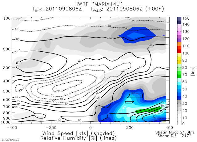
The plot below is the initial condition from HWRF's 06Z run... it's an along-shear cross-section of wind speed and relative humidity.  You can clearly see the asymmetry in the wind field (shaded), as well as the low RH values (contours) being forced into the system by the strong shear.  The official forecast brings Maria over the central Bahamas in 5 days as a strong tropical storm.  Given this track, the southeast and east coast of the US should be very alert... this is nearly a copy of Irene's track.


Tropical Storm Nate is at 45kts, and still virtually stationary.  It's forecast to slowly intensify to a hurricane on Saturday as it begins to crawl to the northwest toward the US/Mexico border next week.  You can view full-resolution visible images of Nate at http://rammb.cira.colostate.edu/ramsdis/online/loop_640.asp?product=tropical_ge_1km_center_relative_vis_floater


Please visit my tropical Atlantic headquarters.