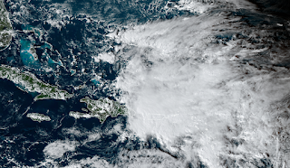
For several days, models have been hinting at the formation of a low pressure system east of the Bahamas, near Hispaniola and Puerto Rico. That has finally happened, so it's time to take it seriously... the odds of this becoming a subtropical or tropical cyclone in the near future are high.

It's nothing but a large area of thunderstorms now, but models are abnormally confident about it developing and heading toward Florida by mid-week. We don't have any of the high-resolution hurricane-specific models available for it yet, so we have to rely on the global models and their ensembles.
From the latest cycle of the American and European ensembles, these are the tracks and positions of the low pressures on Thursday morning.

Then, switching to the deterministic runs from the same cycle, these are the surface pressures and winds valid on Wednesday evening. Don't ever take the details of a 108-hour forecast literally, but these give you an idea of what the two models are doing.

Clearly there's a big difference in intensity, but they agree remarkably well on *something* reaching south-central Florida on Wednesday-Thursday. Whatever it is by then, it will undoubtedly dump several inches of rain on the area. The GFS solution is actually a Category 1-2 hurricane when it reaches the southeast Florida coast, so although not likely, it's not out of the question either.
Also notice the structure of it: it looks likely that the stronger winds (and heavier rain) will be north of the center, not symmetric like a classic tropical storm or hurricane.
One final and significant impact to mention is widespread and prolonged coastal flooding. The winds from this storm will be conducive for onshore flow from the Carolinas down to Florida, then you combine that with already-elevated tides for a few days around Tuesday's full moon, and there could be hundreds of miles of coastal flooding from Monday through Thursday.
Elsewhere, there's a strong low pressure system located east of Bermuda, tagged as Invest 97L. This could also develop into a subtropical or tropical cyclone in the near future, but will innocently track off to the northeast into the north-central Atlantic.
.gif)
The next two names on the list are Nicole and Owen.
- Visit the Tropical Atlantic Headquarters.
- Subscribe to get these updates emailed to you.
- Follow me on Twitter
No comments:
Post a Comment