In true 2020 fashion, Laura and Marco, the 12th and 13th named storms of the season, are both strengthening, and are both forecast to be in the Gulf of Mexico on Monday into Tuesday. Laura became the earliest 12th named storm on record yesterday, and Marco became the earliest 13th named storm on record today... beating the previous record by an astounding eleven days. 2020 has now set the record for earliest C, E, F, G, H, I, J, K, L, and M storms!!

Tropical Storm Laura is passing south of Puerto Rico on Saturday and will reach Hispaniola on Saturday night. Then it is forecast to reach eastern Cuba on Sunday evening, western Cuba by midday Monday, and then into the Gulf of Mexico. The anticipated land interaction with the Greater Antilles will limit its intensification this weekend. But today, while the inner core is south of Puerto Rico over the warm ocean, it is free to strengthen a bit.. and it is.
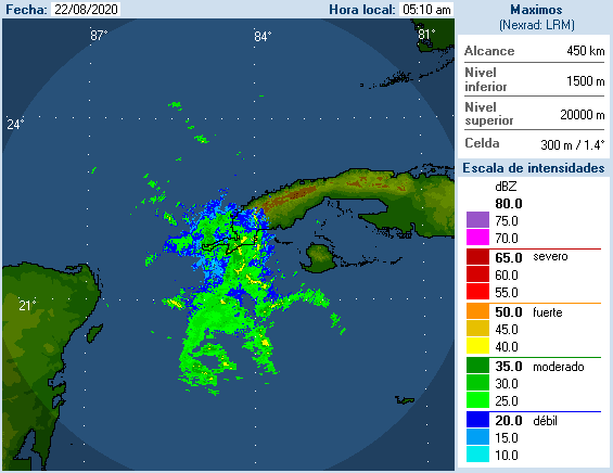
As of the 11am EDT advisory, Laura has peak sustained winds of 40mph and is moving toward the west at 18 mph. Heavy rain and tropical storm force winds are affecting the island... I have long, updating radar loops available at http://bmcnoldy.rsmas.miami.edu/tropics/radar/. The one from Puerto Rico shows the increased organization throughout the day.

The model guidance has continued to nudge southward under the influence of a strong subtropical high pressure ridge to the north. This keeps the storm moving more west than west-northwest, and will almost certainly force it over the Greater Antilles. There is very little model guidance to suggest otherwise. The intensity forecast is tricky of course, because of the land interaction. But NHC is expecting it to reach hurricane status once it enters the Gulf on Monday night. Beyond that, it looks like it's in line to make landfall on the northwest Gulf coast about a day after Marco does. This is certainly unusual, and two consecutive landfalls will bring two separate rounds of heavy rain and two mingled and lingering storm surges. In other words: a mess.

Tropical Storm Marco is passing through the Yucatan Channel today and is developing an eye on radar (not yet evident on satellite images). It will very likely be Hurricane Marco by tonight as it enters the Gulf of Mexico.

It is forecast to track toward the northwest and reach the Gulf coast around Lousiana or Texas on Tuesday. There will be some interference between Laura and Marco, but the most noticeable impact will be an abnormally large swath of heavy rain and multiple coincidences of storm surge at high tide cycles. Marco is currently forecast to weaken to a tropical storm by the time it reaches the coast due to a substantial increase in vertical wind shear.

It's a bit early for the complex storm surge forecasts to begin, but the rainfall forecast over the coming week looks like this so far, with the forecast tracks of Laura and Marco overlaid:

- Visit the Tropical Atlantic Headquarters.
- Subscribe to get these updates emailed to you.
- Follow me on Twitter
No comments:
Post a Comment