
As we head into the end of August, the activity in the tropics is picking up right on schedule. Invest 97L, which was the disturbance in the central Caribbean, is now Tropical Depression 14, and Invest 98L, which was the disturbance east of the Lesser Antilles, is now Tropical Depression 13. The next two names on the list are Laura and Marco.
I will begin with TD13. This young tropical cyclone left the African coast on Saturday, and has been slow to get going. It is still a ragged-looking tropical depression centered about 750 miles east of the Leeward Islands. It is moving toward the west-northwest at 21 mph and is forecast to gradually strengthen. At this pace, it will reach the Windward Islands on Friday afternoon, most likely as a tropical storm. Tropical storm watches are in effect for those islands.

Model guidance is really tight on the track for a few days, bringing it just north of Hispaniola on Saturday night. By Monday morning, the spread increases to include passing over Cuba up to the northern Bahamas, with somewhere in between looking the most likely. That places south Florida squarely in the highest risk area for a landfall or close encounter later on Monday (the 28th anniversary of Hurricane Andrew's landfall).
The intensity is a much more challenging forecast. The environmental factors ahead of it are generally conducive to intensification, aside from a few periods of moderate wind shear. Then exactly how close it passes to Puerto Rico, Hispaniola, and Cuba will have a major influence on how quickly it can strengthen. It if remains far enough away from them, it will tap into very warm water temperatures and be able to strengthen quite a lot.
Since midday yesterday, the regional hurricane models such as HWRF and HMON have consistently been showing at least a Category 3-4 hurricane coming into southeast Florida on Monday. The latest run of the GFS global model now shows the same thing. The notable outlier is the ECMWF global model and its ensemble. Its deterministic run never even develops it into anything beyond a weak depression or open wave, and the vast majority of ensemble members can't track a coherent low either... just 1 of the 51 members bring it to hurricane intensity in the Gulf of Mexico.
This extreme bifurcation of intensity guidance makes it really challenging for NHC to choose a single intensity forecast! That said, the most recent suite of dynamical model guidance is shown below (AVNO is the GFS deterministic run, COTC, HMON, and HWRF are three regional hurricane models). Four of the five dynamical models shown on here have a Category 4 hurricane making landfall in southeast Florida on Monday afternoon. This must be taken seriously.

Beyond Monday, most of the guidance tracks this system south of or across the Florida peninsula and into the Gulf of Mexico. This has implications from the Florida Keys up to Tampa and beyond. This is the most recent GFS ensemble forecast, showing that the Gulf coast should also be paying very close attention to this -- AS WELL AS the southeast coast of the US if it should happen to recurve northward over the Bahamas like Isaias did.

Speaking of the Gulf of Mexico... it might get crowded early next week. TD14 is located in the western Caribbean and has triggered tropical storm watches for northern Honduras. It too is forecast to become a tropical storm shortly, and head north into the Gulf of Mexico. So, we could actually have Laura AND Marco sharing the Gulf of Mexico on Monday, and both making US landfalls on Monday.
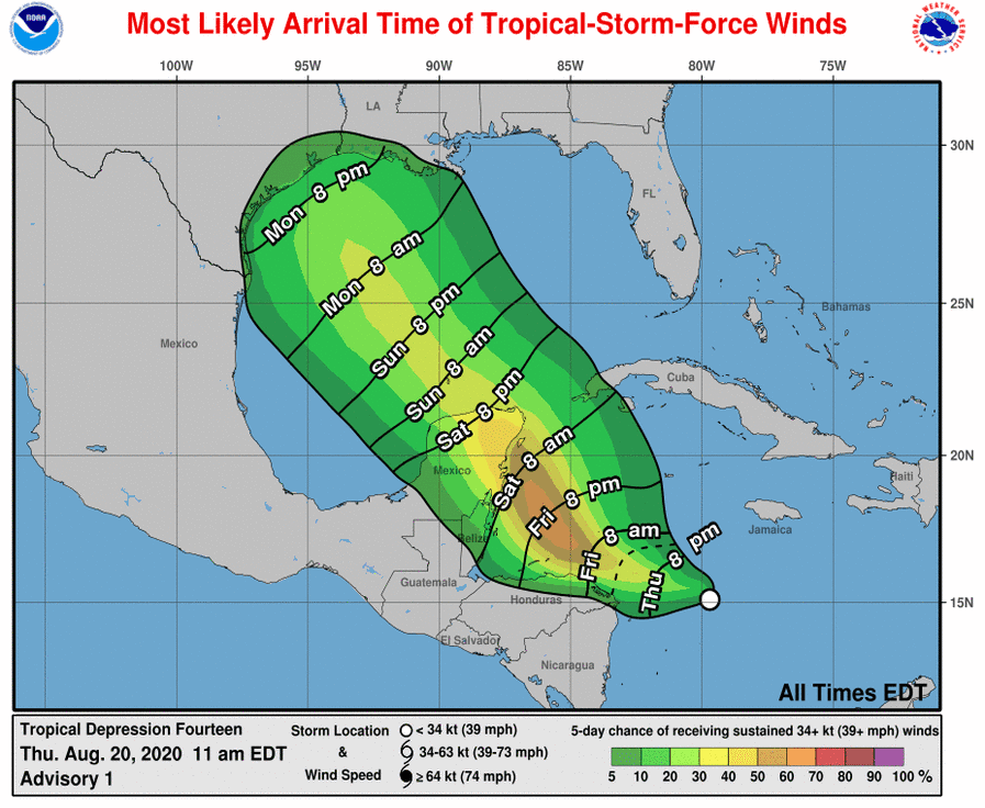
Unlike TD13, there is not much model support for TD14 becoming a major hurricane, but it could actually briefly become a hurricane this weekend as it approaches the Yucatan peninsula. It is expected to weaken later on though as it encounters higher wind shear.
And finally, the National Hurricane Center is giving the wave that's just about to exit the African coast a 40% probability of becoming the next tropical cyclone within the next five days.
- Visit the Tropical Atlantic Headquarters.
- Subscribe to get these updates emailed to you.
- Follow me on Twitter
No comments:
Post a Comment