26 October 2013

Hurricane Mitch: 15 years later

With the combination of a dormant Atlantic right now and another significant anniversary today, I thought I'd write a short summary on Hurricane Mitch, one of the most intense, destructive, and deadly hurricanes in history.

On October 26, 1998, it achieved tropical cyclone perfection in the western Caribbean with a peak intensity of 180 mph (and 905mb central pressure).


Not only was it so close to Honduras and Nicaragua at this intensity (strongest winds were still offshore), but it virtually STALLED, taking five days to drift onto and across Honduras.  In the track map below, the large red circles represent Mitch at its most intense, then it weakened as it drifted slowly southward to landfall.
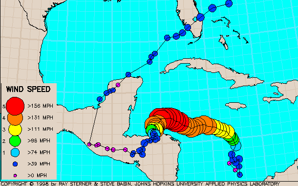

Although the peak winds may have died down prior to official landfall, the rain did not.  Up to 3 feet of rain fell in southern Honduras, but extreme totals were recorded over much of Central America.... and 10"+ amounts were also recorded in many parts of Mexico and then an isolated area in southern Florida as well.  Unofficial local reports in Honduras were up closer to 6 feet of rain.  Mudslides and flooding were especially devastating in Honduras, where about 70% of the country lost power, fresh water, transportation, and communication.

Mitch was responsible for approximately 19,000 deaths across ten countries, but the vast majority were in Honduras (14,600).  It remains the second deadliest hurricane in Atlantic history, trailing slightly behind the Great Hurricane of 1780 that claimed over 22,000 lives in the eastern Caribbean.

Here's your opportunity to stare a Category 5 hurricane in the eye!  Back in 1998, I made a high-resolution visible satellite loop available that is zoomed in over just the inner core.  I know there are folks who were subscribed to my email list/blog back then who are still subscribed, and I remember sharing the details of this monster hurricane with you as it unfolded, including this satellite loop.


This year, at the end of October, we don't have a Mitch, Wilma, or Sandy to worry about... the Atlantic is quiet for now.


24 October 2013

Hurricane history: Sandy and Wilma

SANDY

One year ago this morning, Sandy intensified to a hurricane just south of Jamaica.  By the morning of October 25th, it rapidly intensified to a Category 3 hurricane with 115mph winds as it made landfall on the southeastern coast of Cuba.

Visible satellite image of Hurricane Sandy on the morning of October 24, 2012.
Model guidance was coming into better agreement on a track that would bring Sandy into the New Jersey coast as a very large cyclone on October 29th, possibly not tropical, but still very potent.  Below is a clip from my blog post one year ago:
"The ominous forecast by last night’s ECMWF deterministic run places an incredibly strong cyclone off the New Jersey coast on Monday evening... with tropical storm to hurricane force winds covering every state between Virginia and Maine. A scenario such as this would be devastating: a huge area with destructive winds, extensive inland flooding, possibly heavy snow on the west side, and severe coastal flooding and erosion."
To read the rest of that post, see Sandy strengthens to hurricane on approach to Jamaica; odds of East Coast impact grow

WILMA

Another significant hurricane anniversary is that of Hurricane Wilma in 2005.  On the morning of October 19th, Wilma smashed rapid intensification AND intensity records in the Atlantic when a reconnaissance plane found a central pressure of 882mb.  It went on to hit the Cozumel/Cancun area of the Yucatan peninsula as a high-end Category 4 hurricane, then turned sharply to the northeast with a bullseye on the Florida peninsula.

Wilma's track... intensity is color-coded, and dates are marked at 0000 UTC (the "24" marker is  0000 UTC on Oct 24, or 8pm EDT on Oct 23).
Eight years ago today, Wilma plowed into the southern tip of Florida as a Category 3 hurricane.  I have several long radar loops of Wilma available at http://andrew.rsmas.miami.edu/bmcnoldy/tropics/radar/index.html#wilma05, and a satellite image from shortly after landfall is shown below.


Nearly all of south Florida (west and east coasts) was without power after Wilma went through, and wind gusts over in the Miami/Fort Lauderdale/West Palm Beach area were in the 100mph range.  It left a swath of destruction and flooding from the Keys up to north of Lake Okeechobee.

Not only is it the 8-year anniversary of Wilma's landfall on Florida, it's also the 8-year anniversary of the last time a major hurricane made landfall ANYWHERE in the U.S.!  For a more detailed description of just how odd this major hurricane landfall "drought" is in the U.S., see my blog post from nine days ago: Tropics extremely quiet in Atlantic; record drought in major U.S. hurricane landfalls

As always, thanks for reading and sharing!


23 October 2013

Lorenzo, and an update on the season

On Monday morning, Tropical Storm Lorenzo formed in the middle of the Atlantic (it was initially Tropical Depression 13).  The closest reference point would be Bermuda, but it was even 650 miles southeast of that.  Today, Lorenzo remains a weak tropical storm, and is in a hostile environment with 30kts of vertical shear.  A recent satellite image shows an exposed surface circulation with all of the thunderstorm activity displaced well to the southeast.


As of 5am today, the intensity estimate was 45kts, and it's forecast to weaken/dissipate over the next couple of days.  It will remain very far from any land.  To put its location in another perspective, it's 1900 miles due east of Daytona Beach, FL... the same distance as it is between New York City and Salt Lake City.

As an aside, one year ago today I was writing about newly-formed Tropical Storm Sandy when it was south of Jamaica.  For a haunting trip down memory lane, here's my blog post from October 23, 2012.  Sandy's U.S. landfall occurred on October 29, six days after that post was written.

In the big picture, the season remains extremely quiet... one of the quietest on record.  Although we've had twelve named storms, there have been just two short-lived Category 1 hurricanes, and no major hurricanes (Cat3+).  Going back to 1950, only four other seasons had zero major hurricanes: 1968, 1972, 1986, and 1994.  Of course, this season isn't over yet and we could still have one or more major hurricanes, but as of now, 2013 joins this short list.  In terms of ACE, the season is at about 30% of an average season for this date, and there is nothing expected to form in the foreseeable future.