09 August 2024

Closely watching wave east of Lesser Antilles for development next week

As of today, there are no active tropical cyclones in the Atlantic, and it will probably stay that way through the weekend.  But by early next week that could change.  An easterly wave that just left Africa on Wednesday is presently centered  about 1800 miles east of the Lesser Antilles and is given a 60% probability of development by NHC within the coming week.  The next name on the list is Ernesto.

Visible satellite image from Friday morning. The current center of the disturbance is marked by the orange X and the area of potential formation within the next 7 days is the orange oval.

For the next 2-3 days, this disturbance will be battling dry Saharan air ahead of it and to its north.  But by Monday, most models start perking up when it's about 700 miles east of the Lesser Antilles.  This time of year there are no concerns about the ocean temperature, so dry air, wind shear, and land interaction are the three factors that could put brakes on development. The first two don't look particularly hostile next week, and it won't encounter any substantial landmass until Wednesday at the earliest (Hispaniola). The two maps below show the ensemble-based tracks, color-coded by intensity, from the European model (top) and the American model (bottom) out through next Friday afternoon.


From this early look, this feature will almost certainly cross the Leeward Islands on Tuesday, though there's a lot of spread in the intensity.  Clearly, the European ensemble keeps it weaker for longer, finally reaching upper tropical storm intensity near the latitude of the Bahamas on Thursday-Friday, while the American model's ensemble is far more aggressive with several members bringing it to hurricane intensity by Wednesday.  Keep in mind that global model ensembles are not really great at intensity; they will generally be biased low.

For mainland U.S. interests, the earliest something would reach south Florida currently looks like Friday, if at all.  As of now, there's too much spread to say much beyond that, but it doesn't appear likely.

The most likely scenario presented by the models now is gradual development and intensification, a tropical storm in the vicinity of Puerto Rico on Wednesday, then a turn toward the north when it reaches 70-75°W (the longitudes of Hispaniola to eastern Cuba), followed by much more significant intensification north of the Bahamas.  We'll see if that outlook persists.

Through today's date, here's a look at the total Accumulated Cyclone Energy (ACE) by year.  The value in 2024 is the 6th highest on record, behind 2005, 1933, 1980, 1926, and 1916.  Certainly an impressive start to the season.


Climatologically, the steep uptick in activity is just around the corner though.  We're just wrapping up the typically-quiet first 10 or so weeks of the season; the next 10 weeks are typically not so quiet.


05 August 2024

Debby makes landfall, significant flooding problems coming this week

Since my previous post on Friday morning, there have not been a lot of surprises.  The disturbance of interest did indeed become Tropical Depression 4 on Friday night, then Tropical Storm Debby on Saturday afternoon when its center was west of the Florida Keys.  It tracked northward and briefly attained hurricane status for twelve hours as it made landfall in the Big Bend area of Florida early Monday morning.  From my post on Friday: 
"Climatologically, the fourth named storm forms on August 15, and the second hurricane forms on August 26... so if Invest 97L does become Tropical Storm Debby OR Hurricane Debby, it will be well ahead of the normal pace."

18-hour enhanced infrared satellite loop; landfall was at approximately 11:00 UTC.

I didn't include it in this post, but I have a very long radar animation of Debby available at https://bmcnoldy.earth.miami.edu/tropics/radar/

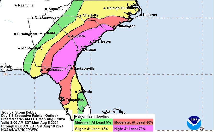
As of Monday afternoon, winds have decreased to tropical storm strength, but the forecast keeps it around for a few more days as it stalls near the coast of the Carolinas.  That stall will be responsible for a very significant flooding threat this week.  This map below shows the five-day rainfall forecast from Debby -- those high totals over northern Florida, Georgia, South Carolina, and North Carolina will undoubtedly be devastating in many locations.


Debby is another perfect example of two important lessons with tropical cyclones:
1) The storm doesn't stop at landfall.  Quite often, there are days of flash flooding and/or tornado threats after landfall and far from the landfall location, so don't tune it out.
2) There's more to the story than the category.  The only thing the category rating of a hurricane tells you is what the peak sustained wind is somewhere in the storm.  However, the large majority of fatalities and damage comes from rainfall and storm surge (i.e., water).  Even a tropical depression can easily produce catastrophic flooding.

Tropical storm warnings are still up for Florida's Big Bend region and then over in eastern GA and SC as Debby is expected to meander back out over the ocean to recharge.


Elsewhere, there's an easterly wave that just crossed the Windward Islands that has a small chance of development in the Caribbean this week... it should reach the Yucatan peninsula area on Friday-Saturday, but as of now it does not appear to be a threat.  The next name on this year's list is Ernesto.


02 August 2024

Debby likely to form this weekend near Florida

An easterly wave has been embedded in dry Saharan air for the past ten days since it left the African coast on July 24.  On Thursday it finally began to show signs of invigorated thunderstorm activity which indicates the dry air is now less of an influence on it.  As of Friday morning, this wave, tagged as Invest 97L, is centered over the eastern tip of Cuba and is forecast to enter the eastern Gulf of Mexico on Saturday.


NHC is giving this a 60% chance of becoming at least a tropical depression through Sunday morning, and 90% through the next seven days.  There's now very good agreement among the models that the center of this will track along the northern Cuba coast through Saturday morning, make a turn toward the northwest and enter the Gulf of Mexico midday Saturday (crossing over or near the Florida Keys), then turn north and track off the west coast of the Florida peninsula from Saturday evening through midday Monday.  Beyond that, some models suggest a bit of a stall over northern Florida, while the majority track it northeastward and intensify it over the Gulf Stream.


As far as intensity forecasts go, there's good agreement on it becoming a tropical storm (its name would be Debby) on Saturday in the Gulf, with a slight chance of reaching hurricane status.  Due to extremely warm water temperatures in the northeast Gulf, the possibility of rapid intensification can't be ignored.

Sea surface temperature (left) and the anomaly (right).
https://bmcnoldy.earth.miami.edu/tropics/sectors/

The most significant impact from this storm, whether it becomes a tropical depression, tropical storm, or even Category 1 hurricane will be the rainfall.  Hefty totals are forecast over the next five days, with the bulk coming Saturday-Monday in Florida then Monday-Wednesday in the Carolinas.  There will undoubtedly be major flooding concerns all along the peninsula and then northward along the coast from there.

Five-day rainfall forecast, ending Wednesday morning.
https://www.wpc.ncep.noaa.gov/#page=qpf

Climatologically, the fourth named storm forms on August 15, and the second hurricane forms on August 26... so if Invest 97L does become Tropical Storm Debby OR Hurricane Debby, it will be well ahead of the normal pace.

Finally, here's a look at how this season's Accumulated Cyclone Energy (ACE) stacks up against the average: roughly 360% of average for the date.  If there's no activity through August 31, this year's total would meet up with the climatological value -- but don't hold your breath.


I will most likely not be available to write posts this weekend, so for the latest reliable information as it develops, keep an eye on the NHC website.