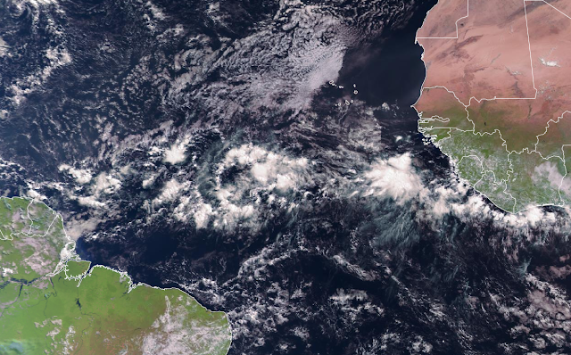
A strong easterly wave left the African coast on Tuesday and has continued to show signs of organization since then. As of Friday morning, it is centered near 30°W longitude, or about 2100 miles east of the southern Windward Islands. The National Hurricane Center is giving it a 60% probability of becoming at least a tropical depression in the next five days. It could become a concern for the Caribbean in 5-10 days. It is currently tagged as Invest 94L, but the next name on the list is Bonnie.
If you think it's awfully early to be looking to Africa for tropical cyclone development, you are exactly right! Last year, Elsa formed in the deep tropics from an African easterly wave on June 30, and in 2018, Beryl formed on July 4 in a similar location. But it's quite rare to have a "successful" easterly wave so early in the season, so the odds are climatologically against this one making it.
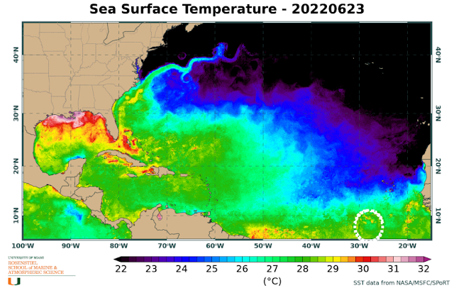
However, ocean temperatures in that area are plenty warm to fuel its development... roughly 28°C -- and that will remain the case as it treks west-northwest. I circled its approximate location on the map below for reference. A rough rule of thumb is that tropical cyclones can develop and intensify with ocean temperatures of 26°C or above, and the warmer it is, the more energy they have to work with.
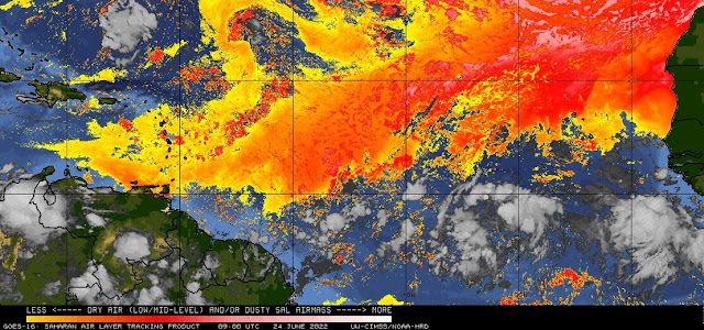
One of big reasons these African easterly waves don't usually start developing so early is large amounts of dry dusty air stream off the continent and cover the deep tropics for much of June and July, suppressing and choking off these nascent cyclones. But this one is sneaking through at a really low latitude, so it's well south of the Saharan air (indicated by the orange and red shading here).
Models are in surprisingly good agreement on it developing, and on it continuing to track west-northwest for at least the next five days. At this rate, it would reach the Windward Islands sometime around June 29, possibly as a tropical storm. Beyond that, the uncertainty naturally increases substantially, but it should remain in the Caribbean for a few days.
Then as you can see in the two ensemble maps here (American above, European below), scenarios include a turn to the northwest or maintaining that west-northwest heading until it reaches Central America. A notable number of ensemble members from both models bring it up to hurricane intensity in the longer range, so it's worth monitoring that trend.
Over the past fifty years, the average date of the second named storm formation is July 24, so if this develops, its location and date would be fairly typical in a month from now.


No comments:
Post a Comment