
Rather than discussing these in alphabetical order, I'll start west and go east. Tropical Depression 22, which had been festering for a long time in the western Gulf of Mexico, was upgraded to Tropical Storm Beta on Friday afternoon. It is forecast to intensify to the season's ninth hurricane shortly as it drifts northwest toward Texas. The map below shows the NHC forecast track, the various tropical storm/hurricane watches and warnings, and the probability of tropical storm force winds.

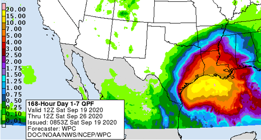
But the hurricane part isn't the problem... it's the drifting. Models have been indicating that Beta will stall near the Texas coast and produce tremendous amounts of rainfall in the coming days. It's essentially a toned-down version of Harvey in 2017 (that was a Category 4 hurricane at landfall and then stalled further north for several days). There's still uncertainty in the track of course, so the exact placement of rainfall maxima is impossible to know this far out, but a large swath of eastern Texas and Louisiana should be preparing for significant flooding.
On to Teddy... tropical storm warnings have been issued for Bermuda as the Category 4 hurricane approaches. Teddy will pass east of the island and spare it from a second major impact in one week, but tropical storm conditions are possible as it zips by on Monday. But then, there's strong agreement among models that it will slam into Nova Scotia on Tuesday, possibly still with hurricane-force winds (even if it's technically not a hurricane anymore).


Moving on to Subtropical Storm Alpha, which made landfall on Portugal's coast on Friday night and has since weakened. This formed from an extratropical low pressure system that NHC began watching for development last Monday night, so it certainly didn't come out of nowhere, but the uncertainty was around whether or not it would acquire subtropical or tropical cyclone characteristics before reaching land -- it did, briefly. As a result, it got named, and Portugal got to usher in the use of the Greek alphabet for Atlantic storms this year.

And finally, we're still keeping an eye on what was Hurricane Paulette. This isn't too surprising though, as many models had been suggesting that it would make a sharp turn to the south and return to warmer waters and possibly regain tropical cyclone characteristics. The turn happened, but the tropical transition has not happened yet. It's presently near the Azores, and has tropical storm-force winds. It also has a lot of smoke from the California wildfires wrapping into the circulation, which shows up here as the milky colors.

Don't believe me? Using NOAA's HYSPLIT model, here's a backward trajectory that I calculated starting at Paulette's present location and going back eight days... the smoky air wrapping into Paulette came directly from southern California.

Wilfred, Alpha, and Beta are the season's 21st, 22nd, and 23rd named storms, which puts this season an incredible 33 days ahead of 2005's record pace. But, 12 of the 23 named storms this year were around for three days or less, and only 2 of the 23 were major hurricanes (Laura and Teddy).
So in terms of ACE (Accumulated Cyclone Energy), the average ACE per storm through today in 2020 is 3.8, while at this point in 2005, it was 8.7. And at this point in 1933, the average ACE/storm was 15.2!
In fact, 2005 isn't even in the top five ACE producing years as of today... the top five are 1933, 1995, 2004, 1926, and 1950. But as of September 19, the ACE is 136% of average for the date -- a big spike after being near-average just a week ago. As you can see below, it's really comparable to 2018 and 2019 as of today.

No comments:
Post a Comment