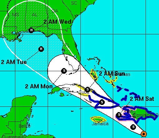
Despite the majority of model guidance and human forecasters, Isaac is still a low-end tropical storm. A recon flight this morning did find winds strong enough to bump the intensity up to 45kts, which is actually the strongest it's ever been (at 65kts, it would become a hurricane). The minimum surface pressure is down to 1000mb, and the center is located just 130 miles south of the southern Dominican Republic coast... moving west at 15mph. A turn to the WNW then NW is expected later today.
Isaac seems to finally be getting its act together, based on aircraft observations and satellite presentation. As you can see in the satellite image above, the exact center of the storm doesn't matter too much... areas hundreds of miles away are feeling the effects of Isaac, both in terms of wind and rain. Tropical storm force winds now extend out to 185 miles from the storm's center. The 5-day forecast cone (yes, it's important not to focus on the exact center of the cone), tropical storm watches (yellow), tropical storm warnings (blue), and hurricane watches (pink) from 8am EDT this morning are shown here, you should look for the latest version at the NHC website.
A huge impact in the coming days will be rain. From the Dominican Republic, Haiti, Jamaica, Cuba, Bahamas, and Florida, then up into the northeast Gulf coast. Much of southern Florida could receive 6-9" in the next few days, with locally higher amounts. Areas in Haiti and Dominican Republic could see 10-20" of rain, and 6-12" in Jamaica and eastern Cuba. Even if Isaac doesn't quite reach hurricane intensity, the rain associated with tropical systems is always a big threat.
JOYCE
Shortly after my update yesterday morning, TD10 was indeed upgraded to TS Joyce as expected... making it the 10th named storm of the season, a full 58 days ahead of climatology! It was also the second earliest date on record to reach the 10th named storm, lagging behind the mega-season of 2005 when Jose became a TS on August 22, and tieing the other mega-season of 1995 with Jerry. This is shaping up to be another astoundingly active season, at least in terms of the number of storms.
However, Joyce's fame was short-lived, and just twelve hours after reaching TS intensity, it weakened to a Depression and is now fizzling out due to formidable shear and dry air. In this messy image below, there are several things being shown. First, the bright green L in the middle is the center of the surface circulation. The background grayscale image is the infrared satellite picture, the yellow lines are the vertical shear magnitude (20kts, 30kts, 40kts, etc), the white lines are the vertical shear direction, and finally, the yellow-orange-red shading denotes the low-mid-level dry air, with redder colors being dustier/drier areas. The point is that Joyce has a LOT working against it! What's left of Joyce is located about 1300 miles west of the northern Cape Verde islands and moving northwest.
AL97
And, it wouldn't be the end of August without having another easterly wave to talk about! A new easterly wave left the African coast yesterday after marching across the continent since August 17 (you can track these waves yourself with the help of a time sequence of infrared images). This wave has a 1007mb embedded Low shown by the red L, and is expected to slowly develop as it heads WNW. It is no immediate threat to anything.
- Visit the Tropical Atlantic Headquarters.
- Subscribe to get these updates emailed to you.
- Follow me on Twitter


No comments:
Post a Comment