
As of the 8am EDT intermediate advisory, Tropical Storm Isaac had 40kt sustained winds and was located about 200 miles east of Guadeloupe in the Leeward Islands. I have a long radar loop from Martinique available which shows the full approach of the storm to the Lesser Antilles, and will continue to run until it's out of range. Other radars will pick it up then, so stay tuned to that link as I add more.
Given its location and intensity forecast, there are quite a lot of hurricane and tropical storm watches/warnings in effect (blue=TS warning, yellow=TS watch, pink=H watch). As of 8am, there are not any hurricane warnings, but that could change later today.

Of course, track and intensity forecasts aren't perfect, and there is still some spread in the various model solutions, and some inherent uncertainty in the official forecast. In the graphic above, the "cone of uncertainty" depicts NHC's average track error over the past 5 years at the different lead times (actually, it's the 67th percentile of their errors). For example, for a 24h forecast, the full width of the cone is 129 miles, while at 120h (5 days), the cone expands to 543 miles across. In addition to that uncertainty, it's important to remember that the storm is big, and the center line or points along the track only symbolize the exact center of the storm. Locations hundreds of miles away from the storm center can still experience severe conditions. Notice that even using the latest cone, the track could be on the west coast of Florida, or stay offshore to the east... both are still very realistic scenarios.
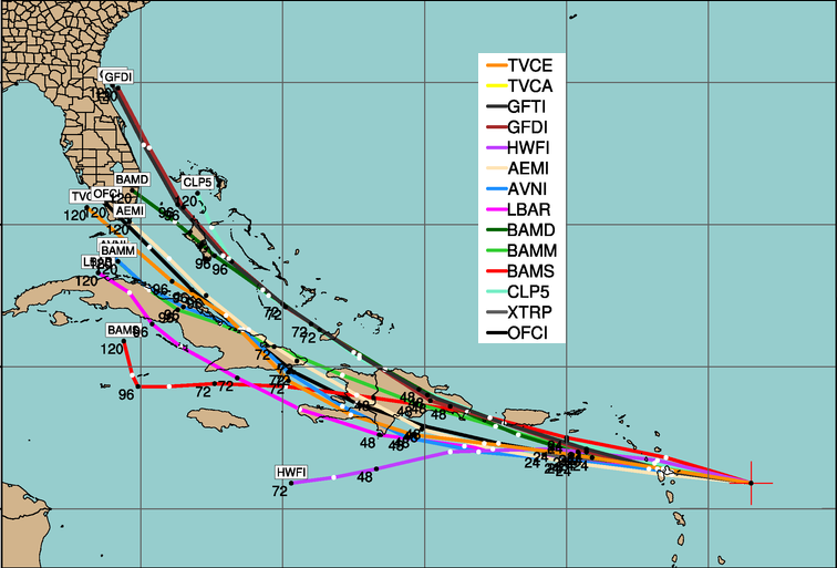
The plot below from my colleague Jonathan Vigh at NCAR/TCGP (we were both formerly at CSU) shows 5-day track forecasts from several models valid at 8am EDT today. Of particular interest is that there was a general nudge to the west with this run compared to previous runs.
Given the large chance for land interactions with Hispaniola and Cuba, Isaac's intensification should be halted for a couple days as it passes over them on Friday and Saturday. But, between its current location and Hispaniola, and then again north of Cuba, conditions are ripe to sustain some substantial intensification. The official forecast keeps it as a Category 1 hurricane through 5 days, but that too can change, so stay tuned. And as I mentioned before, if you're anywhere near the projected path, it's never too early to make your emergency plans and general preparations.
Elsewhere, the easterly wave I've been talking about that exited the African coast on August 18th has been upgraded to Tropical Depression 10. The 1007mb Low is centered about 700 miles west of the Cape Verde islands and tracking WNW. Model guidance suggests that this system will intensify in the coming days, and continue its WNW-NW motion. The next name on the list is Joyce.

- Visit the Tropical Atlantic Headquarters.
- Subscribe to get these updates emailed to you.
- Follow me on Twitter
No comments:
Post a Comment