With the combination of a dormant Atlantic right now and another significant anniversary today, I thought I'd write a short summary on Hurricane Mitch, one of the most intense, destructive, and deadly hurricanes in history.
On October 26, 1998, it achieved tropical cyclone perfection in the western Caribbean with a peak intensity of 180 mph (and 905mb central pressure).
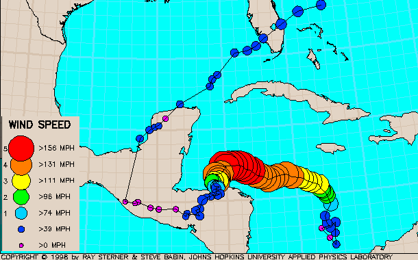
Not only was it so close to Honduras and Nicaragua at this intensity (strongest winds were still offshore), but it virtually STALLED, taking five days to drift onto and across Honduras. In the track map below, the large red circles represent Mitch at its most intense, then it weakened as it drifted slowly southward to landfall.
Although the peak winds may have died down prior to official landfall, the rain did not. Up to 3 feet of rain fell in southern Honduras, but extreme totals were recorded over much of Central America.... and 10"+ amounts were also recorded in many parts of Mexico and then an isolated area in southern Florida as well. Unofficial local reports in Honduras were up closer to 6 feet of rain. Mudslides and flooding were especially devastating in Honduras, where about 70% of the country lost power, fresh water, transportation, and communication.
Mitch was responsible for approximately 19,000 deaths across ten countries, but the vast majority were in Honduras (14,600). It remains the second deadliest hurricane in Atlantic history, trailing slightly behind the
Great Hurricane of 1780 that claimed over 22,000 lives in the eastern Caribbean.
Here's your opportunity to stare a Category 5 hurricane in the eye! Back in 1998, I made a high-resolution visible
satellite loop available that is zoomed in over just the inner core. I know there are folks who were subscribed to my email list/blog back then who are still subscribed, and I remember sharing the details of this monster hurricane with you as it unfolded, including this satellite loop.
This year, at the end of October, we don't have a Mitch, Wilma, or Sandy to worry about... the Atlantic is quiet for now.