08 October 2024

Unfortunately for Florida, Milton's forecast has not changed

Milton continues its trek toward Florida, and very little has changed since yesterday's post.


Overnight, there was an eyewall replacement cycle... this is a common process that intense hurricanes go through periodically in which a larger eyewall develops outside of the original smaller one.  The smaller one decays away and the outer one becomes the only one.  During this process the storm's intensity typically decreases and the wind field expands.  Then, the new eyewall contracts, the storm re-intensifies, and another cycle may begin.  It can happen multiple times in a storm's lifetime.

As of Tuesday afternoon, Milton is a strong Category 4 hurricane and appears to be back on an intensification trend again. Tropical storm conditions are expected to reach the Florida peninsula on Wednesday afternoon, with landfall in the Tampa area late Wednesday night.  Destructive winds and storm surge will of course reach far beyond that area though.


The dire storm surge forecasts have held steady, which is not good news.  Evacuations in the affected areas should be completed by tonight.  You don't want to risk getting stuck in traffic with a major hurricane approaching. To escape storm surge, you don't need to travel very far, even a few miles is often fine if you have a safe place to stay.  Evacuations are based on water, not wind, and for good reason. 


The flooding threat from heavy rain is also extremely high through the central part of the peninsula, but then very little rain is expected in the coming days in the panhandle and down in urban southeast Florida.  Fortunately, Milton will be moving rather quickly as it crosses the state, so the rainfall totals are not uncommonly high for a landfalling tropical cyclone.  I also have a long, updating radar loop set up to monitor rainfall over the state as Milton comes through: https://bmcnoldy.earth.miami.edu/tropics/radar/


And not to throw yet another graphic at you, but this is pretty interesting: right before landfall, 
Milton's inner core will pass over some of the warmest water of its entire journey: 30-31°C (86-88°F), which is 2-3°C (3.5-5.5°F) warmer than average for this time of year.  Although some stronger wind shear should start to weaken the hurricane, it will still be very powerful and this last-minute bit of warmer water won't help.


Leslie weakened to a tropical storm on Tuesday morning after nearly six days a hurricane.  It is forecast to continue weakening and dissipate in the central Atlantic in a very uneventful fashion.

Those two areas of potential formation that I pointed out in yesterday's post are still in the outlook and are both at a 20% probability for formation within a week.


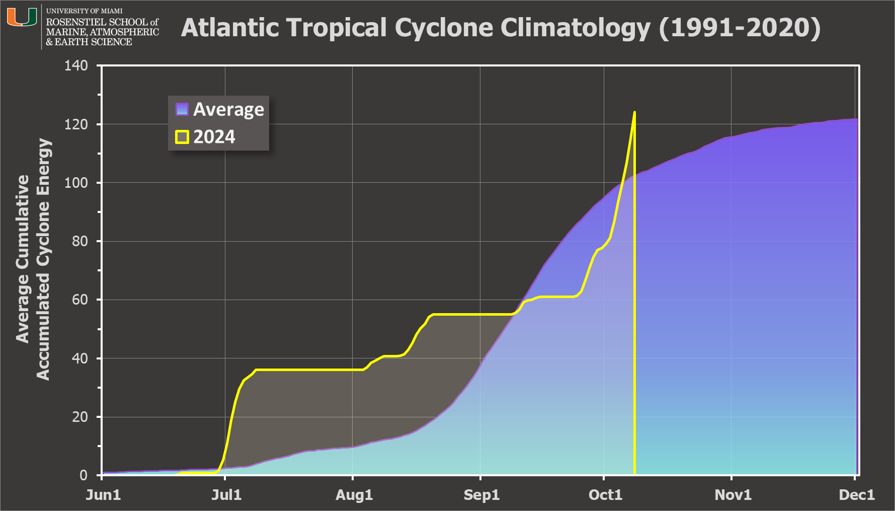
For those keeping track of Accumulated Cyclone Energy (ACE), today is actually a noteworthy day: the value accrued just surpassed the average amount during an entire average season today.  So with Leslie and Milton still active, it will continue to climb.
07 October 2024

Milton explosively intensifies in western Gulf, warnings issued for Florida


In one of the most explosive rounds of intensification in recorded history, Milton's peak winds increased from 90 mph at 2am EDT on Monday to 175 mph at 2pm then 180 mph at 5pm.  It went from a Category 1 to a Category 5 hurricane in just nine hours.  This satellite animation reveals the minimal vertical wind shear as evident by the thin whispy ice clouds drifting around as well as a pinhole eye that is just 8 miles in diameter.  Record warm water temperatures also played a big role in facilitating this.


With 180 mph peak winds, there have only been five other Atlantic hurricanes that had higher peak intensities: Allen 1980 (190),  Labor Day 1935 (185), Gilbert 1988 (185), Dorian 2019 (185), and Wilma 2005 (185), There have been three others that tied the 180 mph mark.

The storm's intensity and central pressure were very well measured throughout the day by multiple reconnaissance flights by both NOAA and the Air Force.  It has also been in radar range from Sabancuy, Mexico, and its tiny and intense inner core shows up very well from there too.

https://bmcnoldy.earth.miami.edu/tropics/radar/

As of 5pm EDT on Monday, Milton is a Category 5 hurricane (the season's second) located just north of the Yucatan peninsula.  It still has two more days over water until it reaches the Florida peninsula on Wednesday evening.  Those peak winds will decrease somewhat as wind shear picks up closer to landfall, but that absolutely does not diminish the threat it poses. Any preparations and evacuations across Florida should be well underway and wrapped up ASAP, or at the latest, before Wednesday morning when tropical storm conditions could arrive.


The storm surge forecasts for the Tampa area and surrounding coastline are catastrophically high, with 10-15 feet possible in the central part of the peninsula.  Do not hesitate any longer to evacuate if told to -- this is as dire as it gets.

The afternoon suite of HTI graphics is shown below and you can always find the most recent at https://www.weather.gov/srh/tropical#hti which are zoomable and interactive.


Also, don't forget that the Florida peninsula is skinny -- the hurricane will quickly cross over to the east side, bringing hurricane conditions and dangerous storm surge there as well.

Milton will undoubtedly join other October "M" Category 5 hurricanes in retirement: Mitch (1998), Matthew (2016), and Michael (2018).  Milton was actually the replacement name for Michael in this list.

And just to keep tabs on Kirk and Leslie, Kirk has transitioned to an extratropical cyclone and will reach northern France on Wednesday, while Leslie is still maintaining hurricane intensity in the central Atlantic.  It is forecast to weaken this week and be out of the picture this weekend.

Elsewhere across the basin, there's an easterly wave still over Africa that NHC is giving a 30% chance of formation once it exits the continent, and a disturbance near south Florida with a 10% chance as it heads toward the northeast.

06 October 2024

Dire days ahead for Florida as Milton intensifies


Milton is still a tropical storm in the western Gulf of Mexico as of late Sunday morning, but is very close to reaching hurricane intensity.  It will track eastward across the Gulf of Mexico and reach the Florida peninsula late Wednesday; however, significant impacts will begin before that.

Overlay of all five track forecast cones from NHC spanning when TD14 first formed on Saturday morning through late Sunday morning.  The cone only represents where the center of the storm may track with 2/3 probability; it does not show where impacts will be experienced.

The forecasts from the models and NHC have been fairly stable (not varying much from run to run), which continues to paint a dire picture for many parts of already-storm-ravaged western Florida.  There is strong agreement on a track toward the central part of the peninsula, with a landfall late Wednesday, and at an intensity of at least a Category 3 hurricane.

Not only is there relatively light vertical wind shear in the Gulf right now, the water temperature is still record-breaking warm.  And it's not just warm in terms of the sea surface temperature, but also through a depth as measured by ocean heat content.  High ocean heat content provides a hurricane with a constant source of fuel and makes it much harder to upwell cooler water from below which could weaken the storm.  This will help Milton to rapidly intensify and reach a higher peak intensity.

https://bmcnoldy.earth.miami.edu/tropics/ohc/

The Sunday 11am forecast from NHC brings it to nearly Category 4 intensity at landfall on Wednesday afternoon/evening.  There is too much uncertainty to know exactly where landfall will be, but forecasts have been focused between Tampa and Fort Myers.  For most hazards, the exact landfall location doesn't matter, but for peak storm surge it does. There is a world of difference between being just north of the eye with offshore winds and just south of the eye with onshore winds.  Prepare assuming you're going to be on the bad side.

Preparations should be completed by the time tropical storm conditions could arrive, which for this storm looks like early Wednesday morning along much of the peninsula.


In addition to the devastating wind and storm surge impacts from a forecast like that, the entire peninsula is already experiencing widespread heavy rain today and that will continue until the hurricane passes through on Thursday morning. The map below shows the five-day outlook of flash flood risk.


It's still slightly too early get watches and warnings for Florida, but they could start being issued as early as Sunday evening, certainly by Monday morning. Be prepared to see storm surge warnings with ominous peak values on parts of the west coast of the peninsula.  Many of these areas are still cleaning up after Helene's storm surge, but this is very likely going to be worse.  Don't wait to leave if told to.

Elsewhere, Kirk and Leslie are still both hurricanes in the central Atlantic.  Leslie will weaken before reaching any land, but Kirk is still forecast to reach northern Europe on Wednesday.  As I brought up several times before, it will most likely not be technically "tropical" by then and it will weaken relative to what it is now, but impacts from wind and storm surge will still be felt.