Tropical Storm Florence will threaten the U.S. east coast later in the week, Tropical Storm Helene is affecting the Cabo Verde islands right now, and Tropical Depression Nine is poised to become Tropical Storm Isaac very soon, though not immediately affecting land.
 |
| Enhanced infrared satellite image of the tropical Atlantic. Florence, Tropical Depression Nine, and Helene are scattered across the basin. (tropicaltidbits.com) |
Although it is still just below hurricane strength, the environment is expected to favor substantial intensification in the next five days, and the official forecast from the National Hurricane Center brings a strong Category 4 Hurricane Florence ominously close to the southeast and mid-Atlantic coast by Thursday morning. If you are in the Jacksonville to Cape Hatteras line, now is the time to begin the preliminary preparations. As time goes on, the area of greatest concern will become more focused, but impacts such as rainfall and storm surge will blanket a large portion of the coastline regardless of if and where it makes a direct landfall.
Both the European and U.S. global models and their ensembles support this, with very few outliers missing the United States coast now. They have been consistent (or trending) with this for several days.
For some historical perspective, I created a map showing the tracks of all major hurricanes (Category 3+) that made a direct landfall between Jacksonville and Cape Hatteras since 1851. There have been only ten: Fran 1996, Hugo 1989, Gracie 1959, Hazel 1954, and six unnamed hurricanes prior to 1900. This would be a rare event, and plenty of residents have probably never experienced anything like it.
 |
| Tracks of the ten major hurricanes that made landfall between Jacksonville and Cape Hatteras since 1851. |
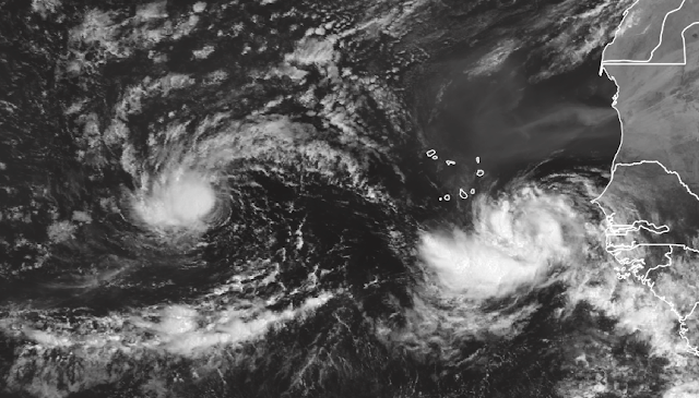
The visible satellite image below shows TD9 (pre-Isaac) and Helene, and the animated map of ensemble forecasts above gives you an idea of which way each is likely to go in the coming days. Future-Isaac looks like it will remain at low latitudes, reaching the Lesser Antilles by Wednesday night, probably as a hurricane. Helene will likely find a weakness in the subtropical ridge and slide northward into the open Atlantic this week.
 |
| Tropical Depression Nine (left) and Tropical Storm Helene (right). (EUMETSAT) |
- Visit the Tropical Atlantic Headquarters.
- Subscribe to get these updates emailed to you.
- Follow me on Twitter


No comments:
Post a Comment