 |
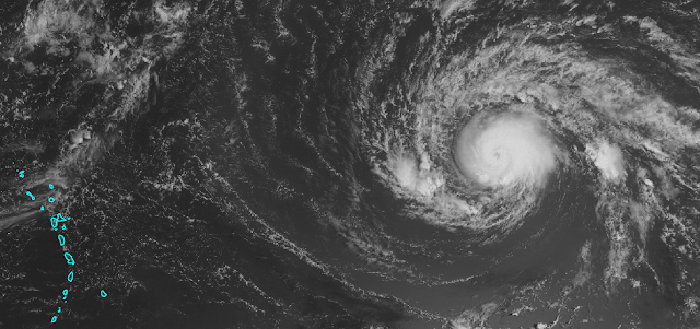
| Regional satellite image with Hurricane Irma on the right and the Lesser Antilles on the left. (NASA) |
The National Hurricane Center forecast brings it up to Category 4 intensity by Wednesday, but it could happen sooner. From this point forward, it will encounter warmer and warmer ocean temperatures, and the vertical wind shear remains quite low.
The long-range model guidance has shifted slightly north again, meaning an earlier recurvature appears more likely -- though not certain. Recurvature is when storms in the deep tropics that move generally westward start turning toward the north and the mid-latitudes.
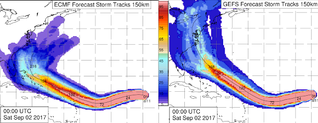
Both the European and the U.S. global models and their ensembles have significantly backed off on the threat of this storm entering the Caribbean and the Gulf of Mexico, shifting the highest probabilities toward the U.S. east coast or offshore.
 |
| Ensemble-based track probabilities out to 10 days from the ECMWF (left) and GFS (right). (A. Brammer, UAlbany) |
For the U.S. east coast, **IF** the storm were to head that direction, the Sep 9-11 timeframe is the most likely as of now for landfall or a close encounter, with options ranging from south Florida (earlier in that window) to New England (later in that window). Early next week, the Leeward Islands and Puerto Rico could be affected, then the Bahamas, the entire U.S. east coast, and Bermuda should be watching this as the days go on, and to take care of routine hurricane preparedness tasks now, before it's urgent.
You can always find the most recent NHC forecast at http://www.nhc.noaa.gov/
- Visit the Tropical Atlantic Headquarters.
- Subscribe to get these updates emailed to you.
- Follow me on Twitter

No comments:
Post a Comment