28 October 2011

Rina passes over Cancun, weakens to a Depression

Since yesterday's update, Rina became even less organized and lost what little deep convection it had.  This was well-timed for Mexico though, since Rina made landfall on Playa del Carmen (the mainland city directly west of Cozumel) at 03Z today (late Thursday night for them) then passed over Cancun.  Its 9-hour traverse over land, combined with the increasingly hostile environment, was responsible for the downgrade to a 30kt Depression at 15Z today.  All that remains is a tiny harmless low-level swirl just off the northeastern tip of the Yucatan peninsula.  For a very Wilma-like origin and track, thankfully the intensity didn't follow suit.

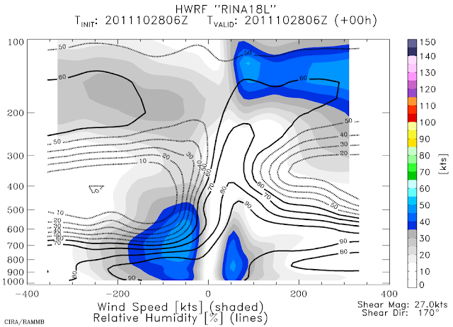
The image below shows a vertical cross-section taken along the shear vector (southerly) from one of the regional hurricane models (HWRF's 06Z analysis).  The fields shown on there are the wind speed (shaded) and relative humidity (lines).  It's easy to see how weak and shallow the vortex is, and the intrusion and overriding of very dry air... the analyzed shear is 27kts too.  This is not an environment that a storm can redevelop in.


Rina is forecast to lose its remaining tropical characteristics and degenerate to a remnant low very shortly, meandering around in the same vicinity due to weak steering flow.

Please visit my tropical Atlantic headquarters.
Subscribe to get these updates emailed to you.

27 October 2011

Rina downgraded to Tropical Storm

In a battle against increasing vertical shear, Rina was downgraded to a 60kt tropical storm at 15Z today.  The center is located just south of Cozumel and heading NNW at 5kts. You can also track it on Cancun's radar: http://smn.cna.gob.mx/radares/cancun/cancun.php


Now that it has weakened and the convective area associated with it has shrunk drastically, it is steered by different layers of the atmosphere.  Deeper systems are steered by a deeper layer, and weaker/shallower systems are steered by a lower and shallower layer.  That said, the forecast track now calls for Rina to stall in place, just meandering around in a loop waiting for some stronger steering flow to pick it up.  The track plot in the map below shows forecasts from 3 dynamical models, and the NHC forecast is basically an average of these.  The thin light lines are prior 00Z forecasts and can be ignored.  The official intensity forecast also follows the model guidance closely: gradual weakening over the next several days.


Please visit my tropical Atlantic headquarters.
Subscribe to get these updates emailed to you.

25 October 2011

Rina nearly a major hurricane

In the past day, Rina has intensified to a 95kt hurricane, with a high likelihood of reaching 100kts... it would become the season's 4th major hurricane.  Visually, it has become a beautiful symmetric storm, with delicate outflow cirrus expanding uniformly away from the center.

It has another couple of days to enjoy a low-shear environment, then as it heads further north toward Cuba, the upper-level winds become quite a bit more hostile.  But in the meantime, the ocean below it is extremely warm not just at the surface, but is warm quite deep too (that minimizes upwelling effects that slow-moving systems are prone to).  The map below shows the depth of the 26C water... Rina's current location has some of the deepest warm water in the entire Atlantic basin.


The forecast is still quite tricky because of the weak steering environment.  In the next few days, it should continue its slow crawl to the N-NW, but after that, its future depends on whether or not it gets "picked up" by a passing mid-latitude trough.  If it does, it will make a turn to the NE and head for Cuba and then Florida... if it doesn't, it should meander slowly to the west or even stay approximately stationary.
Basically... Mexico, Cuba, and Florida should all be watching this very closely.
Some additional strengthening is still possible, and for at least the next day, there's no reason Rina can't strengthen quite a bit.


Please visit my tropical Atlantic headquarters.
Subscribe to get these updates emailed to you.

24 October 2011

Rina becomes season's 6th hurricane

In what was a somewhat expected rapid intensification (based on satellite presentation), Rina was upgraded to a 65kt hurricane at 18Z today.  The central pressure is 991mb, and it's still crawling north at 4kts.  And again, given its appearance and environment, it's quite likely that additional intensification will occur, perhaps reaching Category 3 status by tomorrow.  In the visible satellite image below, you can already see an eye forming:

Full zoop (zoomed out):
http://rammb.cira.colostate.edu/ramsdis/online/loop_640.asp?product=tropical_ge_4km_visir2_floater_2

Please visit my tropical Atlantic headquarters.
Subscribe to get these updates emailed to you.
Rina forms in western Caribbean

The disturbance off the coast of Nicaragua that I mentioned in Friday's update has gotten much better organized... and on Sunday at 21Z was upgraded to TD18, then six hours later, to TS Rina.  This is the 17th named storm of the season; climatologically by this date we have had just ten named storms.

At 15Z today, Tropical Storm Rina's intensity is 40kts, with a 1001mb central pressure... and an appearance that suggests some hefty intensification can be expected.  It's currently located north of the eastern tip of Honduras, and the forecast track calls for a very slow crawl toward the northern tip of the Yucatan peninsula.  The majority of models bring this system up to hurricane intensity by Wednesday.


This time of year, this location, and this track forecast are very similar to Wilma (2005)... but so far, we aren't dealing with a Category 5 hurricane.  At Rina's position, Wilma was a Category 5 storm six years and five days ago.  This map below is for Wilma... NOT Rina:


There's also a disturbance in the far eastern Caribbean that is worth keeping an eye on...


Please visit my tropical Atlantic headquarters.
Subscribe to get these updates emailed to you.

21 October 2011

Disturbance festering in southwestern Caribbean

For nearly a week now, there has been an area of disturbed weather in the extreme southwestern Caribbean.  It's origins appear to be a combination of a  tail of a cold front and the ambient monsoon depression.  There is a 1010mb Low associated with the disturbance, and the low-level center is approximately 200 miles off the Nicaraguan coast.

The system is in a low-shear environment, and the shear is expected to remain below 20kts for at least the next several days.  The SST is and will be nearly 30C.  There is not yet a lot of model guidance for this, but the global models indicate that it will develop and VERY slowly crawl northward toward Cuba as it intensifies.  Certainly something to keep a very close eye on, since the western Caribbean during time of year has birthed some infamous Category 5 hurricanes: Hattie 1961, Mitch 1998, and Wilma 2005.  The plot below shows the tracks of 11 storms that formed in October in the western Caribbean and became major hurricanes.  Note the relatively tight track pattern... north toward Cuba and Florida (Hattie, Mitch, and Wilma are the 3 that first went west before recurving/dissipating).  If named, the next name on the list is Rina (replaces Rita from 2005).


Please visit my tropical Atlantic headquarters.
Subscribe to get these updates emailed to you.

06 October 2011

Philippe becomes a hurricane after 12 days

The first advisory was written on Philippe on Sept 24th, and since then, it has fluctuated in intensity from 35-60kts, but never dropped to a depression, and never made it to a hurricane... until this morning.  At 15Z today, Philippe's estimated intensity was 70kts and 985mb, making it the 5th hurricane of the season.  It's located about 415 miles southeast of Bermuda and moving NNE at 8kts.

However, this is also its last gasp as a tropical system.  Over the next couple of days, it will encounter SSTs nearing 20C and vertical shear up to 50kts and it will become an extratropical storm then finally merge with its mid-latitude trough.

To support the 70kt hurricane classification, the microwave image below (from NRL in Monterey CA... at 1023Z this morning) shows what appears to be an eye and eyewall, and definitely some strong tightly-curved rainbands.  The latest visible and infrared images are indeed showing a slightly clearing eye... I included an enhanced visible image from 1445Z below the microwave image so you don't just have to take my work for it!


Please visit my tropical Atlantic headquarters.

03 October 2011

Ophelia turns extratropical, Philippe still a TS

At 15Z today, the final advisory was written for Ophelia... 18 days after it left the African coast and 13 days after it was first classified as a tropical storm.  Over the weekend, the storm reached a peak intensity of 120kts and 940mb (Category 4) as it passed 140 miles east of Bermuda.  It's presently a 50kt extratropical cyclone and just passed over Newfoundland (exactly the same landfall location as Maria 17 days ago!).


Early Saturday morning, it did indeed pass very close (just 5.4 miles west!!!) to Buoy 41049 as I mentioned.  The buoy reported 40ft waves, wind gusts up to 100kts, and a pressure of 952mb.  The plot below was made using hourly data from the buoy:

Philippe is still hanging around, and is still a tropical storm.  Surprisingly though, on Sunday morning, it was nearly a hurricane!  It reached an intensity of 60kts and 993mb, but has since weakened again to 55kts.


It is forecast to continue westward for another 24-36 hours, then recurve abruptly into the north central Atlantic.

Please visit my tropical Atlantic headquarters.