As of Thursday morning, Eta is a sprawling and struggling tropical depression... in fact, perusing some surface observations and satellite data, it's hard to even identify a surface center anymore. But there's at least a defined mid-level circulation. Whatever is left of Eta is expected to drift toward Belize in the coming day and the center should be back over warm water by Friday morning -- at which point it could start re-organizing. But will it? Probably.
A deep trough over the central U.S. will guide the storm northeast toward Cuba and then toward the Gulf of Mexico and/or Florida. It's difficult to say anything meaningful about the intensity at that point because that all hinges on how quickly it rebuilds on Friday-Saturday. But one thing that is shaping up to look like a big threat is extremely heavy rain over Cuba and south Florida. This 7-day forecast rainfall accumulation map (Thursday morning through next Thursday morning) shows some rather high values from West Palm Beach down to Key West! Some locations in there have already had among their wettest years on record.
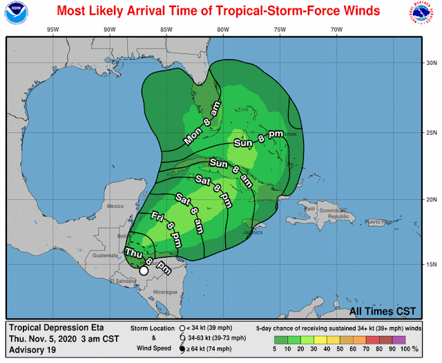
Taking the latest NHC forecast as-is (there's a lot of uncertainty), tropical storm conditions *could* arrive in south Florida in the Sunday evening to early Monday morning timeframe, but heavy rain will begin well before that. This forecast will definitely evolve, so Cuba and south Florida: pay close attention to updated forecasts at https://www.nhc.noaa.gov/graphics_at4.shtml?start#contents
These two ensemble runs from the European and American models show relatively good agreement in the next 3-4 days, then rapidly-growing spread 5-6 days out, and huge spread 7-10 days out. So don't take any long-range forecast literally; there's a lot of uncertainty!
South Florida has had just one known hurricane encounter during November, and that was November 4, 1935. But there have been a few tropical storm encounters during November, the most recent being Mitch on November 5, 1998.
 Since Monday morning's update, Eta did indeed continue to rapidly intensify, reaching an upper-end Category 4 hurricane that slowly drifted in to make landfall in Nicaragua on Tuesday afternoon. It has expectedly weakened significantly over the mountainous terrain of Nicaragua and Honduras and is now a very disorganized tropical depression centered over Honduras. The question is: what happens next?!


Thanks
ReplyDeleteYou don't get many comments here Brian but be assured I watch your emails closely all summer long and I'm sure others do also. Thanks for all your coverage.
ReplyDeleteH Davis
Thank you for your info and updates.
ReplyDeleteAppreciate your updates very much!
ReplyDelete