 |
| Tropical Storm Harvey and Invest 92L on Friday morning. (CIRA/RAMMB) |

Model agreement is very tight on the forecast track: it will reach Belize and the Yucatan peninsula on Tuesday-Wednesday and very likely as a strong tropical storm or Category 1 hurricane. It will affect the same areas that Franklin did two weeks prior. Beyond the Yucatan peninsula encounter, things get hazy... but the possibility exists that it could become a hurricane in the Gulf of Mexico in about a week. At this point, it's just something to be aware of, not concerned about.
Elsewhere, the tropical wave right behind (east) of Harvey is also a feature of interest. Currently termed Invest 92L, it would become Tropical Depression Ten or Tropical Storm Irma if/when it develops into a tropical cyclone -- maybe today?

Since it is centered a few hundred miles further north than Harvey, the steering currents are also different -- and rather than cruising westward through the Caribbean, it is forecast to track toward the west-northwest through the next five days. That trajectory brings it near south Florida late Tuesday into Wednesday.

However, as of now, none of the reliable global or regional models do much of anything with it in terms of intensity. When it arrives in the vicinity of south Florida on Tuesday into Wednesday, it is an open wave in model-land, having been weakened by mid-level dry air and moderate shear. Those days could still be breezy and stormy, but given the current guidance, it is not expected to be anything too noteworthy.
But it's important to point out that there is some risk associated with placing so much confidence in models. We are looking at a tropical disturbance, maybe even a tropical cyclone, tracking over the Bahamas and toward south Florida in the 4th week of August... climatology would not suggest completely dismissing the threat which would be just four days away from now. South Floridians should be watching this one closely.
Also, since my last update on Monday, Gert did indeed reach hurricane intensity, and was actually a Category 2 hurricane for 18 hours as it recurved into the north central Atlantic. It has been absorbed into an extratropical cyclone, but was the season's second hurricane and the strongest storm of the season so far.
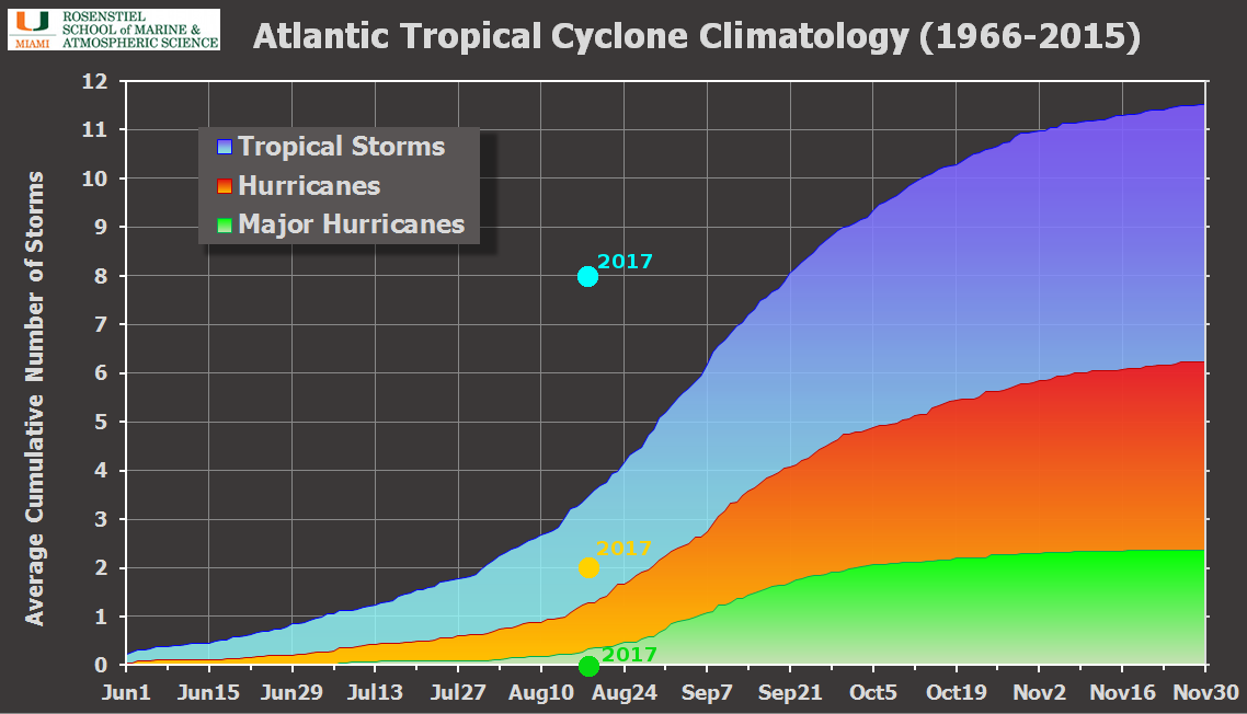
In terms of seasonal metrics, we are at eight named storms, two hurricanes, and no major hurricanes, with an Accumulated Cyclone Energy (ACE) of 16.2. Using the past fifty years as climatology, the average for this date is three named storms, one hurricane, no major hurricanes, and an ACE of 14.9. The last time there were this many named storms at this point in the season was 2012, and before that: 2005. Both were extremely active seasons.
- Visit the Tropical Atlantic Headquarters.
- Subscribe to get these updates emailed to you.
- Follow me on Twitter
No comments:
Post a Comment