Tropical Depression 3 has still not formed, though the easterly wave we've been watching since it left the African coast last Friday remains a close contender. It has a closed surface circulation, but the thunderstorm activity associated with it has been marginal (not always centralized, and not always persistent). It's now centered about 650 miles east of Trinidad, or 1100 miles east-southeast of Puerto Rico.
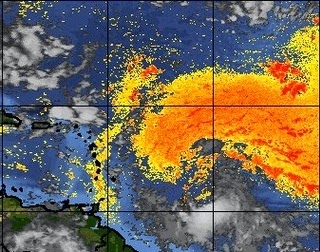
 |
| Visible satellite image from 7:45am EDT. The limited thunderstorm activity is displaced to the south and southeast of the exposed surface circulation. |
One thing that human forecasters and computer models admittedly have a hard time evaluating is dry air and how much it will impact a developing system. The majority of necessary factors for development have been reasonably hospitable over the last few days, but it has been tracking along the south edge of some very dry air. If the circulation were isolated and self-contained throughout the depth of the vortex, that dry air would not play a big role and the storm would probably already be a hurricane. But, if there's a route for that dry air to get entrained into the circulation, development is choked off and the result is what we've seen this week so far.
Here's an image that shows infrared satellite data in grays, and the strength of the Saharan Air Layer (SAL) in yellows-reds. Once the disturbance gets out closer to the Lesser Antilles, the SAL is barely present, and the environment is more moist. Using an average speed of 5°/day, the wave should be moving out of the dry air by Friday morning.
 |
| Infrared image with Saharan Air Layer data overlaid. (CIMSS) |
Models continue to forecast intensification, which they've been doing all along and have all been wrong (model agreement and confidence does not always translate to the real world!!). But, if the dry air becomes less of a factor soon, it *should* finally develop. This morning's track forecasts look similar to what we've been seeing, just a delayed northward turn. Be aware that at the later times in this forecast, the storm could actually be a hurricane (small probability, but not impossible).
.png) |
| Track forecasts from 3 global and 3 regional models (06Z runs). For reference, 120 hours from this run would be valid early Tuesday morning. (B.Tang at UAlbany.) |
Yesterday, I included a comparison of tracks for storms that passed within 100 miles of the wave's location during July/August and September/October. The historical July/August tracks were very few and very weak. Using this morning's position, and the same 100 mile buffer and the same July/August period, the historical map looks VERY different. Now it includes 16 tracks, 5 of which became major hurricanes. Several even turned north toward the Bahamas like this one is still expected to do.
 |
| Tracks of all tropical cyclones that passed within 100 miles of where the easterly wave is centered today during July and August (1851-2013). The Cat3+ ones that turned toward the north are David 1979, Betsy 1965, and Unnamed 1893. |
Brian, I am taking a cruise out of Fort Lauderdale, leaving Saturday evening, and heading to Haiti on Monday morning. What are the odds of this storm impacting the cruise (directly or indirectly with rough seas)? Thanks!
ReplyDeleteWell, leaving on Saturday out of Fort Lauderdale won't be a problem. If Haiti experiences anything from this, it should be mostly confined to Sunday. By Monday, it's expected to be north of Haiti. The cruise ship will avoid any bad weather if necessary. Sunday's portion of the cruise could be a little choppy/stormy if this develops.
ReplyDelete